Fine Art Print > Animals > Mammals > Cats (Domestic) > Russian White
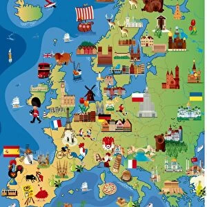
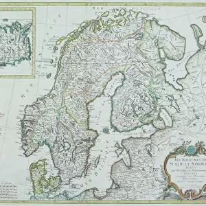
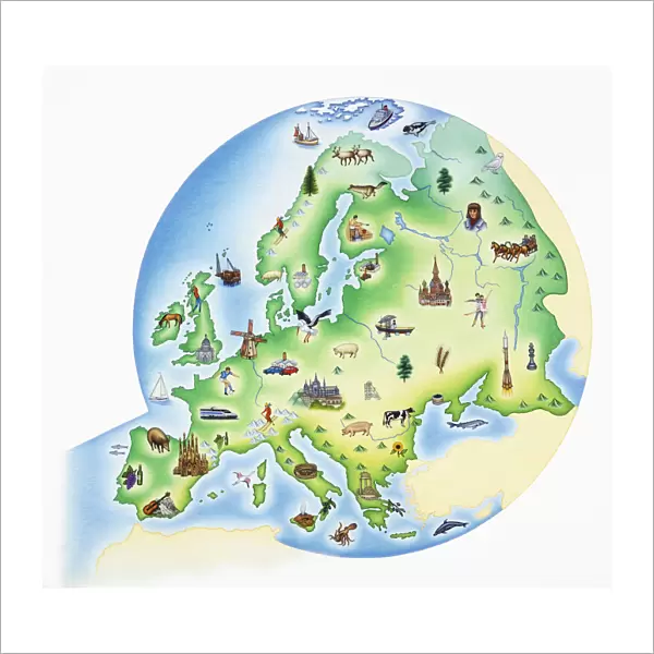
Fine Art Print : Map of Europe with illustrations of famous landmarks and items associated with various countries


![]()
Fine Art Prints from Fine Art Storehouse
Map of Europe with illustrations of famous landmarks and items associated with various countries
Unleash your creativity and transform your space into a visual masterpiece!
Dorling Kindersley
Media ID 13558379
© This content is subject to copyright
British Isles Countries Earth Finnish Lapland Former Soviet Union French Culture Geographical Locations Geography German Culture Great Britain Illustrations Irish Republic Italian Culture Landmarks Lapland Large Group Of Objects Russia Russian Culture Scandinavia Shoreline Tourist Attractions Ussr World
20"x20" (+3" Border) Fine Art Print
Discover the rich cultural tapestry of Europe with our exquisite Fine Art Prints from Dorling Kindersley at Media Storehouse. This stunning Map of Europe comes alive with vibrant illustrations of iconic landmarks and cherished symbols from each beloved country. From the Eiffel Tower in France to the Leaning Tower of Pisa in Italy, and the Brandenburg Gate in Germany to the Windmill in Holland, this captivating print is a celebration of Europe's diverse heritage. Bring a piece of Old World charm into your home or office with this beautiful and intricately detailed work of art. Order now and let the stories of Europe unfold before your eyes.
20x20 image printed on 26x26 Fine Art Rag Paper with 3" (76mm) white border. Our Fine Art Prints are printed on 300gsm 100% acid free, PH neutral paper with archival properties. This printing method is used by museums and art collections to exhibit photographs and art reproductions.
Our fine art prints are high-quality prints made using a paper called Photo Rag. This 100% cotton rag fibre paper is known for its exceptional image sharpness, rich colors, and high level of detail, making it a popular choice for professional photographers and artists. Photo rag paper is our clear recommendation for a fine art paper print. If you can afford to spend more on a higher quality paper, then Photo Rag is our clear recommendation for a fine art paper print.
Estimated Image Size (if not cropped) is 50.8cm x 46.5cm (20" x 18.3")
Estimated Product Size is 66cm x 66cm (26" x 26")
These are individually made so all sizes are approximate
Artwork printed orientated as per the preview above, with landscape (horizontal) orientation to match the source image.
FEATURES IN THESE COLLECTIONS
> Animals
> Fishes
> G
> Grouper
> Animals
> Mammals
> Cats (Domestic)
> Russian White
> Arts
> Artists
> O
> Oceanic Oceanic
> Europe
> Finland
> Related Images
> Europe
> Germany
> Related Images
> Fine Art Storehouse
> Map
> Italian Maps
> Fine Art Storehouse
> Photo Libraries
> Dorling Kindersley Prints
EDITORS COMMENTS
This print by Dorling Kindersley showcases a vibrant and detailed "Map of Europe with illustrations of famous landmarks and items associated with various countries". Bursting with color, this image transports us to the diverse landscapes and rich cultures that make up the European continent. From the British Isles to Scandinavia, this horizontal map takes us on an enchanting journey through geographical locations that have shaped history. The white background allows each illustration to stand out, capturing our attention as we explore every corner of this magnificent map. Famous landmarks such as the Eiffel Tower in France, the Colosseum in Italy, and Germany's Brandenburg Gate are beautifully depicted alongside iconic symbols representing Russian culture or German traditions. This large group of objects represents not only physical geography but also serves as a visual celebration of European heritage. As we follow the coastline along Spain's shores or venture into Lapland's snowy landscapes, it becomes clear that this map is more than just a tool for navigation; it is an invitation to travel destinations filled with wonder and awe-inspiring beauty. Whether you're planning your next adventure or simply appreciate artistry combined with educational value, this Map of Europe print will undoubtedly captivate your imagination. Let it transport you across borders and immerse yourself in the richness and diversity that Europe has to offer.
MADE IN AUSTRALIA
Safe Shipping with 30 Day Money Back Guarantee
FREE PERSONALISATION*
We are proud to offer a range of customisation features including Personalised Captions, Color Filters and Picture Zoom Tools
SECURE PAYMENTS
We happily accept a wide range of payment options so you can pay for the things you need in the way that is most convenient for you
* Options may vary by product and licensing agreement. Zoomed Pictures can be adjusted in the Cart.