Fine Art Print > Africa > Democratic Republic of the Congo > Lakes > Related Images
Fine Art Print : Map illustrating the Closing Phases of the East African Campaign, 1917-18, (c1920)
")

![]()
Fine Art Prints from Heritage Images
Map illustrating the Closing Phases of the East African Campaign, 1917-18, (c1920)
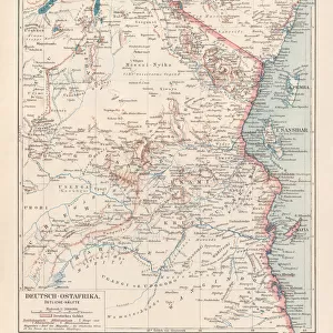
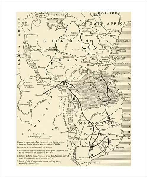
Map illustrating the Closing Phases of the East African Campaign, 1917-18, (c1920). European powers in Africa during the First World War: Shaded area showing Territory still held by the enemy in German East Africa at the beginning of 1917; Coastal areas held by British troops; General von Lettow-Vorbecks track from December 1916 to his surrender on November 14, 1918; Colonel Tafels line of retreat from the Mohenge district until his surrender on November 27, 1918; Track of the Wintgens-Naumann raiding force, February-October 1917. From " The Great World War: A History", Volume IX, edited by Frank A Mumby. [The Gresham Publishing Company Ltd, London, c1920]
Heritage Images features heritage image collections
Media ID 19666065
© The Print Collector/Heritage Images
Belgian Congo British East Africa Coastline Colonies Colony Congo East Africa East African Campaign Frank A Frank A Mumby Frank Arthur Frank Arthur Mumby Front Line Frontline German East Africa German East African Campaign Gresham Publishing Co Ltd Gresham Publishing Company Imperialism Indian Ocean Keystone Archives Lines Mozambique Mumby Mumby Frank A Mumby Frank Arthur Nyasaland Position Positions Rhodesia Rhodesia Africa The Great World War A History Theatre Of War Battlefield Lake Malawi Lake Nyasa
20"x16" (+3" Border) Fine Art Print
Step back in time with our exquisite selection of Fine Art Prints from Media Storehouse. This captivating piece, "Map illustrating the Closing Phases of the East African Campaign, 1917-18," is an unknown masterpiece from Heritage Images, circa 1920. The map provides a fascinating glimpse into European powers' territorial claims during the First World War in Africa. Add an air of historical intrigue to your home or office with this beautifully detailed and preserved print. Each print is carefully produced using high-quality materials, ensuring vibrant colors and sharp details that bring history to life.
20x16 image printed on 26x22 Fine Art Rag Paper with 3" (76mm) white border. Our Fine Art Prints are printed on 300gsm 100% acid free, PH neutral paper with archival properties. This printing method is used by museums and art collections to exhibit photographs and art reproductions.
Our fine art prints are high-quality prints made using a paper called Photo Rag. This 100% cotton rag fibre paper is known for its exceptional image sharpness, rich colors, and high level of detail, making it a popular choice for professional photographers and artists. Photo rag paper is our clear recommendation for a fine art paper print. If you can afford to spend more on a higher quality paper, then Photo Rag is our clear recommendation for a fine art paper print.
Estimated Image Size (if not cropped) is 37.6cm x 50.8cm (14.8" x 20")
Estimated Product Size is 55.9cm x 66cm (22" x 26")
These are individually made so all sizes are approximate
Artwork printed orientated as per the preview above, with portrait (vertical) orientation to match the source image.
FEATURES IN THESE COLLECTIONS
> Africa
> Democratic Republic of the Congo
> Lakes
> Related Images
> Africa
> Malawi
> Lakes
> Lake Nyasa
> Africa
> Malawi
> Lakes
> Related Images
> Africa
> Malawi
> Related Images
> Africa
> Mozambique
> Lakes
> Lake Nyasa
> Africa
> Mozambique
> Lakes
> Related Images
> Africa
> Mozambique
> Maps
> Africa
> Mozambique
> Related Images
> Africa
> Related Images
EDITORS COMMENTS
This print showcases a detailed map illustrating the closing phases of the East African Campaign during 1917-18. The map, taken from "The Great World War: A History" provides a comprehensive overview of the European powers' presence in Africa during World War I. It highlights various significant locations and tracks related to this campaign. The shaded area represents the territory still held by the enemy in German East Africa at the beginning of 1917, while coastal areas are shown as being under British control. The map also traces General von Lettow-Vorbeck's track from December 1916 until his surrender on November 14,1918. Additionally, it depicts Colonel Tafel's line of retreat from the Mohenge district until his surrender on November 27,1918. Another notable feature is the track of the Wintgens-Naumann raiding force between February and October 1917. This image offers insights into key military movements and positions during this period. With its historical significance, this print serves as a valuable resource for understanding colonialism, imperialism, and warfare in early twentieth-century Africa. It sheds light on how European powers vied for control over territories such as German East Africa (present-day Tanzania) and their impact on local populations. Preserved by Heritage Images, this photograph captures an important chapter in world history that shaped not only Africa but also global geopolitics during that time.
MADE IN AUSTRALIA
Safe Shipping with 30 Day Money Back Guarantee
FREE PERSONALISATION*
We are proud to offer a range of customisation features including Personalised Captions, Color Filters and Picture Zoom Tools
SECURE PAYMENTS
We happily accept a wide range of payment options so you can pay for the things you need in the way that is most convenient for you
* Options may vary by product and licensing agreement. Zoomed Pictures can be adjusted in the Cart.