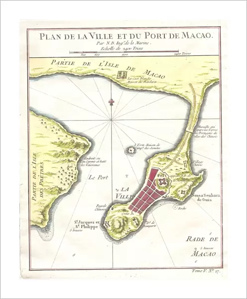
Fine Art Print : 1750, Bellin Map of Macao Hong Kong China, topography, cartography, geography, land


![]()
Fine Art Prints from Liszt Collection
1750, Bellin Map of Macao Hong Kong China, topography, cartography, geography, land
1750, Bellin Map of Macao Hong Kong China
Liszt Collection of nineteenth-century engravings and images to browse and enjoy
Media ID 14006658
© Artokoloro Quint Lox Limited
1750 Antique Map Latitude Longitude Mappa Mundi Old Antique Plan Old Antique View Ols Antique Map Rare Old Maps Topo
20"x16" (+3" Border) Fine Art Print
Discover the rich history and intricate detail of the past with our exquisite Fine Art Print from the Media Storehouse collection. This stunning representation is taken from the 1750 Bellin Map of Macao, Hong Kong, China, from the esteemed Liszt Collection. A masterpiece of cartography and geography, this topographical map showcases the landforms and territories of the region as they appeared over 250 years ago. Bring a piece of historical significance and artistic beauty into your home or office with this impressive Fine Art Print.
20x16 image printed on 26x22 Fine Art Rag Paper with 3" (76mm) white border. Our Fine Art Prints are printed on 300gsm 100% acid free, PH neutral paper with archival properties. This printing method is used by museums and art collections to exhibit photographs and art reproductions.
Our fine art prints are high-quality prints made using a paper called Photo Rag. This 100% cotton rag fibre paper is known for its exceptional image sharpness, rich colors, and high level of detail, making it a popular choice for professional photographers and artists. Photo rag paper is our clear recommendation for a fine art paper print. If you can afford to spend more on a higher quality paper, then Photo Rag is our clear recommendation for a fine art paper print.
Estimated Image Size (if not cropped) is 40.6cm x 50.7cm (16" x 20")
Estimated Product Size is 55.9cm x 66cm (22" x 26")
These are individually made so all sizes are approximate
Artwork printed orientated as per the preview above, with portrait (vertical) orientation to match the source image.
EDITORS COMMENTS
This print showcases the intricate and detailed 1750 Bellin Map of Macao Hong Kong China. A true masterpiece in topography, cartography, and geography, this vintage map takes us back to a bygone era of exploration and discovery. The artist's skillful illustration brings to life the landforms, rivers, and coastlines of this region with remarkable accuracy. The carefully plotted grid lines denote latitude and longitude, allowing for precise navigation across these ancient lands. Every stroke on this paper exudes history and artistry. As we gaze upon this rare old map, we are transported through time to an era when maps were not just tools but also works of decorative beauty. Its aged appearance adds a touch of nostalgia as we contemplate the journeys taken by those who relied on such maps for their explorations. This antique map serves as a window into the past—a mappa mundi that reveals both the known world at that time and the vast spaces yet to be discovered. It reminds us of our connection to previous generations who traversed these very regions in search of new horizons. Whether you are an avid collector or simply appreciate historical artifacts, this Bellin Map print is sure to captivate your imagination with its rich heritage and timeless allure.
MADE IN AUSTRALIA
Safe Shipping with 30 Day Money Back Guarantee
FREE PERSONALISATION*
We are proud to offer a range of customisation features including Personalised Captions, Color Filters and Picture Zoom Tools
SECURE PAYMENTS
We happily accept a wide range of payment options so you can pay for the things you need in the way that is most convenient for you
* Options may vary by product and licensing agreement. Zoomed Pictures can be adjusted in the Cart.