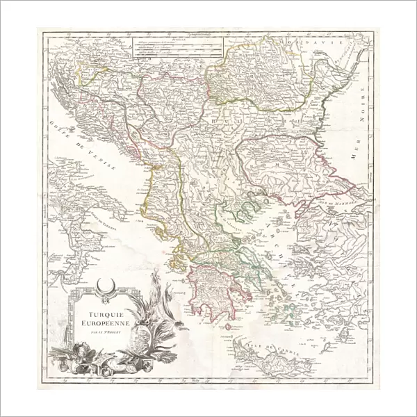
Fine Art Print : 1752, Vaugondy Map of Greece, Macedonia and Albania, topography, cartography, geography


![]()
Fine Art Prints from Liszt Collection
1752, Vaugondy Map of Greece, Macedonia and Albania, topography, cartography, geography
1752, Vaugondy Map of Greece, Macedonia and Albania
Liszt Collection of nineteenth-century engravings and images to browse and enjoy
Media ID 14004609
© Artokoloro Quint Lox Limited
1752 Antique Map Latitude Longitude Mappa Mundi Old Antique Plan Old Antique View Ols Antique Map Rare Old Maps Topo
20"x20" (+3" Border) Fine Art Print
Discover the captivating beauty of the past with our exquisite fine art print from the Media Storehouse collection. This stunning 1752 Vaugondy Map of Greece, Macedonia, and Albania, from the esteemed Liszt Collection, showcases intricate topography, cartography, and geography of the region during the 18th century. Bring a piece of historical cartography into your home or office, and transport yourself to a time of exploration and discovery. This fine art print makes a perfect addition to any space, whether as a standalone piece or as part of a collection. Experience the rich history and intricate detail of this beautiful map, now available in a limited edition print.
20x20 image printed on 26x26 Fine Art Rag Paper with 3" (76mm) white border. Our Fine Art Prints are printed on 300gsm 100% acid free, PH neutral paper with archival properties. This printing method is used by museums and art collections to exhibit photographs and art reproductions.
Our fine art prints are high-quality prints made using a paper called Photo Rag. This 100% cotton rag fibre paper is known for its exceptional image sharpness, rich colors, and high level of detail, making it a popular choice for professional photographers and artists. Photo rag paper is our clear recommendation for a fine art paper print. If you can afford to spend more on a higher quality paper, then Photo Rag is our clear recommendation for a fine art paper print.
Estimated Image Size (if not cropped) is 48.1cm x 50.8cm (18.9" x 20")
Estimated Product Size is 66cm x 66cm (26" x 26")
These are individually made so all sizes are approximate
Artwork printed orientated as per the preview above, with portrait (vertical) orientation to match the source image.
EDITORS COMMENTS
This print showcases the exquisite "1752, Vaugondy Map of Greece, Macedonia and Albania". A true masterpiece in cartography, this topographical representation offers a fascinating glimpse into the geography of these ancient lands. The intricate details and precision displayed on this vintage map are truly awe-inspiring. The carefully drawn lines depict latitude and longitude, creating a grid that allows for accurate navigation across the region. Every contour is meticulously illustrated to showcase the diverse landscapes found within Greece, Macedonia, and Albania. From majestic mountains to winding rivers and sprawling coastlines, this map captures it all. Steeped in history and rich with cultural significance, this old-world artifact takes us back in time to an era when exploration was at its peak. It serves as a reminder of our ancestors' thirst for knowledge about the world around them. Adorned with decorative elements that add charm to its overall aesthetic appeal, this antique map is not only a valuable historical document but also a work of art. Its aged appearance adds character while evoking nostalgia for times long gone. Whether you're an avid traveler or simply fascinated by ancient civilizations, this remarkable piece from the Liszt Collection will transport you on an extraordinary journey through time and space.
MADE IN AUSTRALIA
Safe Shipping with 30 Day Money Back Guarantee
FREE PERSONALISATION*
We are proud to offer a range of customisation features including Personalised Captions, Color Filters and Picture Zoom Tools
SECURE PAYMENTS
We happily accept a wide range of payment options so you can pay for the things you need in the way that is most convenient for you
* Options may vary by product and licensing agreement. Zoomed Pictures can be adjusted in the Cart.