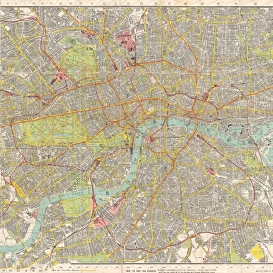
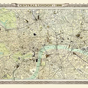
Fine Art Print : 1899, Bacon Pocket Plan or Map of London, topography, cartography, geography, land


![]()
Fine Art Prints from Liszt Collection
1899, Bacon Pocket Plan or Map of London, topography, cartography, geography, land
1899, Bacon Pocket Plan or Map of London
Liszt Collection of nineteenth-century engravings and images to browse and enjoy
Media ID 14008141
© Artokoloro Quint Lox Limited
1899 Antique Map Latitude Longitude Mappa Mundi Old Antique Plan Old Antique View Ols Antique Map Rare Old Maps Topo
21"x14" (+3" Border) Fine Art Print
Step back in time with our exquisite selection from the Media Storehouse Fine Art Prints range. This captivating piece showcases the 1899 Bacon Pocket Plan or Map of London, a treasure from the Liszt Collection. Delve into the rich history of cartography, geography, and topography with intricate details of London's landmarks as they appeared over a century ago. Bring a piece of historical charm into your home or office, and transport yourself back to an era of horse-drawn carriages and bustling streets. Order now and let this stunning print tell a story that spans generations.
21x14 image printed on 27x20 Fine Art Rag Paper with 3" (76mm) white border. Our Fine Art Prints are printed on 300gsm 100% acid free, PH neutral paper with archival properties. This printing method is used by museums and art collections to exhibit photographs and art reproductions.
Our fine art prints are high-quality prints made using a paper called Photo Rag. This 100% cotton rag fibre paper is known for its exceptional image sharpness, rich colors, and high level of detail, making it a popular choice for professional photographers and artists. Photo rag paper is our clear recommendation for a fine art paper print. If you can afford to spend more on a higher quality paper, then Photo Rag is our clear recommendation for a fine art paper print.
Estimated Image Size (if not cropped) is 53.3cm x 35.5cm (21" x 14")
Estimated Product Size is 68.6cm x 50.8cm (27" x 20")
These are individually made so all sizes are approximate
Artwork printed orientated as per the preview above, with landscape (horizontal) orientation to match the source image.
EDITORS COMMENTS
This print showcases the remarkable "1899, Bacon Pocket Plan or Map of London". Immerse yourself in a journey through time as you explore this exquisite piece of topography, cartography, and geography. The intricate details displayed on this vintage map transport you to an era long gone by. Every line and contour on this ancient paper serves as a testament to the artistry and precision that went into its creation. With its decorative elements and historical significance, it is more than just a mere map; it is a window into the past. As your eyes wander across the delicate grid lines denoting latitude and longitude, you can't help but marvel at how such an intricate web of information was meticulously crafted without modern technology. This rare old map holds within it not only geographical knowledge but also whispers of countless journeys taken by those who relied on its guidance. The faded colors evoke a sense of nostalgia while reminding us that history continues to shape our present reality. Whether you are an avid traveler or simply fascinated by the world's wonders, this antique treasure will undoubtedly ignite your curiosity for exploration. Let this extraordinary print from Liszt Collection transport you back in time as you uncover London's rich heritage through the lens of cartographic excellence.
MADE IN AUSTRALIA
Safe Shipping with 30 Day Money Back Guarantee
FREE PERSONALISATION*
We are proud to offer a range of customisation features including Personalised Captions, Color Filters and Picture Zoom Tools
SECURE PAYMENTS
We happily accept a wide range of payment options so you can pay for the things you need in the way that is most convenient for you
* Options may vary by product and licensing agreement. Zoomed Pictures can be adjusted in the Cart.