Fine Art Print > Europe > Italy > Sicily > Messina
Fine Art Print : Portolan atlas by Joan Martines (1556-1590). Western
. Western")


![]()
Fine Art Prints from Mary Evans Picture Library
Portolan atlas by Joan Martines (1556-1590). Western
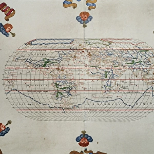
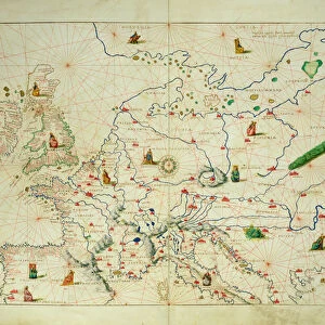
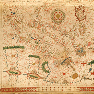
Portolan atlas of the world by Joan Martines (1556-1590). Messina, 1587. Western Mediterranean. National Library. Madrid. Spain
Mary Evans Picture Library makes available wonderful images created for people to enjoy over the centuries
Media ID 14406606
© Thaliastock / Mary Evans
1587 Area Atlas Balearic Biblioteca Cartography Chart Colours Continent Element Geography Illuminated Nacional Cartographical Cosmographer
21"x14" (+3" Border) Fine Art Print
Discover the captivating allure of the past with Media Storehouse's exquisite range of Fine Art Prints. This offering showcases a rare and intriguing piece from the annals of cartography - the Portolan Atlas by Joan Martines (1556-1590). Dating back to 1587, this Western Mediterranean map, housed in the National Library of Madrid, Spain, is a testament to the rich cartographic traditions of the time. With its vibrant colors and meticulous detail, this fine art print transports you back to an era of exploration and discovery. Each print is meticulously reproduced from the original source, ensuring the highest quality and authenticity. Bring a touch of history and artistry into your home or office with this stunning Portolan Atlas Fine Art Print from Media Storehouse.
21x14 image printed on 27x20 Fine Art Rag Paper with 3" (76mm) white border. Our Fine Art Prints are printed on 300gsm 100% acid free, PH neutral paper with archival properties. This printing method is used by museums and art collections to exhibit photographs and art reproductions.
Our fine art prints are high-quality prints made using a paper called Photo Rag. This 100% cotton rag fibre paper is known for its exceptional image sharpness, rich colors, and high level of detail, making it a popular choice for professional photographers and artists. Photo rag paper is our clear recommendation for a fine art paper print. If you can afford to spend more on a higher quality paper, then Photo Rag is our clear recommendation for a fine art paper print.
Estimated Image Size (if not cropped) is 35.5cm x 53.3cm (14" x 21")
Estimated Product Size is 50.8cm x 68.6cm (20" x 27")
These are individually made so all sizes are approximate
Artwork printed orientated as per the preview above, with portrait (vertical) orientation to match the source image.
FEATURES IN THESE COLLECTIONS
> Africa
> Related Images
> Animals
> Mammals
> Muridae
> Western Mediterranean Mouse
> Animals
> Mammals
> Muridae
> Western Mouse
> Europe
> Italy
> Related Images
> Europe
> Italy
> Sicily
> Messina
> Europe
> Spain
> Related Images
EDITORS COMMENTS
This stunning image showcases a page from the Portolan Atlas created by Joan Martines in Messina, Sicily, in 1587. Dated to the late 16th century, this atlas is a testament to the rich cartographical knowledge of the time. The intricately detailed map depicts the Western Mediterranean, with a focus on the African coast and the Balearic Islands. The vibrant colors and decorative elements add an artistic touch to the informative chart, making it not only a valuable resource for geographical knowledge but also a beautiful work of art. Joan Martines, a cosmographer, painstakingly illustrated each map in the atlas with meticulous attention to detail. The map is adorned with decorative elements, including elaborate borders and colorful illustrations of cities and coastal towns. The use of color adds depth and dimension to the map, making it easier to distinguish between different regions and bodies of water. The map highlights the Western Mediterranean, with the African continent extending to the bottom of the page. The intricate detailing of the African coastline reveals the extensive exploration and knowledge of the region during this period. The Balearic Islands, located in the western Mediterranean, are also prominently featured, with their individual islands clearly marked. This Portolan Atlas is a significant historical artifact, providing valuable insights into the geographical knowledge of the late 16th century. Its intricate detailing and decorative elements make it a beautiful work of art, showcasing the intersection of cartography and art during this period. The map is currently housed in the Biblioteca Nacional de España in Madrid, Spain, where it continues to inspire and intrigue scholars and visitors alike.
MADE IN AUSTRALIA
Safe Shipping with 30 Day Money Back Guarantee
FREE PERSONALISATION*
We are proud to offer a range of customisation features including Personalised Captions, Color Filters and Picture Zoom Tools
SECURE PAYMENTS
We happily accept a wide range of payment options so you can pay for the things you need in the way that is most convenient for you
* Options may vary by product and licensing agreement. Zoomed Pictures can be adjusted in the Cart.