Home > North America > United States of America > Maps
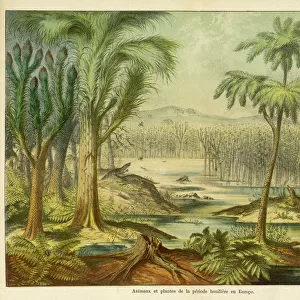
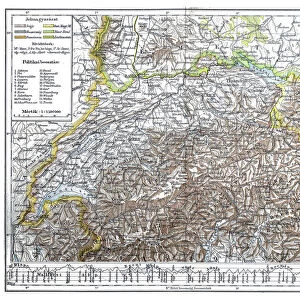
Alps Geological Map 1895

![]()
Wall Art and Photo Gifts from Fine Art Storehouse
Alps Geological Map 1895
Meyers Conversation Lexicon. A reference book of general knowledge, 5th edition 17 volumes Bibliographisches Institut - Leipzig 1895-1897
Unleash your creativity and transform your space into a visual masterpiece!
THEPALMER
Media ID 13611851
© This content is subject to copyright
Atlas Mythological Figure European Alps Geology Paper World Map
FEATURES IN THESE COLLECTIONS
> Europe
> Related Images
> Fine Art Storehouse
> The Magical World of Illustration
> Palmer Illustrated Collection
> Fine Art Storehouse
> Map
> Historical Maps
> Fine Art Storehouse
> Map
> USA Maps
> Maps and Charts
> Early Maps
> Maps and Charts
> Geological Map
> Maps and Charts
> World
> North America
> United States of America
> Maps
EDITORS COMMENTS
This print showcases an exquisite piece of history - the "Alps Geological Map 1895" from Meyers Conversation Lexicon. This reference book, published in Leipzig between 1895 and 1897, holds a wealth of general knowledge within its seventeen volumes. The map itself is a remarkable illustration that takes us back to a time when cartography was meticulously crafted by hand. The image depicts the European Alps in stunning detail, with intricate engravings showcasing the region's physical geography. Every contour line and elevation plan has been carefully etched onto paper, creating an antique masterpiece that transports us to another era. It serves as a testament to human curiosity and our desire to understand the world around us. As we gaze upon this mesmerizing artwork, we are reminded of the vastness and beauty of our planet. The mountains rise majestically against a backdrop of otherworldly landscapes, inviting us to explore their grandeur. This map not only provides valuable geological information but also evokes a sense of wonderment about our natural surroundings. "The Alps Geological Map 1895" by THEPALMER is more than just an artistic representation; it is a window into both scientific knowledge and historical craftsmanship. Its presence on display invites viewers to appreciate the artistry involved in creating such detailed maps while igniting their imagination about distant lands waiting to be discovered.
MADE IN AUSTRALIA
Safe Shipping with 30 Day Money Back Guarantee
FREE PERSONALISATION*
We are proud to offer a range of customisation features including Personalised Captions, Color Filters and Picture Zoom Tools
SECURE PAYMENTS
We happily accept a wide range of payment options so you can pay for the things you need in the way that is most convenient for you
* Options may vary by product and licensing agreement. Zoomed Pictures can be adjusted in the Cart.