Home > Asia > Armenia > Maps
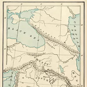
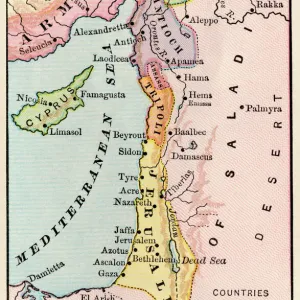
Antique map of Palestine

![]()
Wall Art and Photo Gifts from Fine Art Storehouse
Antique map of Palestine
Unleash your creativity and transform your space into a visual masterpiece!
Hemera Technologies
Media ID 13609501
© Getty Images
16th Century 16th Century Style Arabia Armenia Border Cyprus Direction Document Geography Holy Land Land Legend Location Mediterranean Sea Middle East Object Palestine Palestinian Place Positioning Red Sea Region Scale Shelter Syria Tent Territory Golan Heights
FEATURES IN THESE COLLECTIONS
> Asia
> Cyprus
> Related Images
> Fine Art Storehouse
> Map
> Historical Maps
> Maps and Charts
> Early Maps
EDITORS COMMENTS
This print showcases an exquisite antique map of Palestine, dating back to the 16th century. With its rich historical significance and intricate details, this archival piece offers a glimpse into the past, revealing the region's geographical features and cultural heritage. The map encompasses not only Palestine but also neighboring territories such as Arabia, Armenia, Cyprus, Syria, and Golan Heights. The expertly engraved cartography highlights key locations within the Holy Land while depicting borders and scales with precision. As we explore this vintage masterpiece further, our eyes are drawn to the Mediterranean Sea on one side and the Red Sea on the other—testaments to Palestine's strategic positioning in relation to these bodies of water. Intriguing elements like a tent symbolize shelter amidst ancient landscapes while a legend provides insight into symbols used throughout the map. This horizontal composition immerses us in a world where physical geography intertwines with history. Preserved by Hemera Technologies' meticulous craftsmanship, this color image transports us back in time without any human presence distracting from its allure. It is impossible not to appreciate both its artistic value and educational potential for those interested in Middle Eastern history or cartographic studies. Whether displayed in homes or educational institutions alike, this antique map of Palestine serves as a tangible reminder of our collective past—a testament to how art can bridge gaps between generations through visual storytelling.
MADE IN AUSTRALIA
Safe Shipping with 30 Day Money Back Guarantee
FREE PERSONALISATION*
We are proud to offer a range of customisation features including Personalised Captions, Color Filters and Picture Zoom Tools
SECURE PAYMENTS
We happily accept a wide range of payment options so you can pay for the things you need in the way that is most convenient for you
* Options may vary by product and licensing agreement. Zoomed Pictures can be adjusted in the Cart.