Home > North America > United States of America > New York > New York > Maps
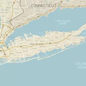
Vintage Map of New York

![]()
Wall Art and Photo Gifts from Fine Art Storehouse
Vintage Map of New York
Vintage Map of New York at the beginning of the 18th Century. from 1880
Unleash your creativity and transform your space into a visual masterpiece!
duncan1890
Media ID 13666625
© duncan1890
18th Century 18th Century Style American Culture Cartographer Chart Connecticut Eastern Usa Ephemera Geographical Locations Illustrations And Vector Art Image Created 18th Century Long Beach Long Island Manufactured Object Mid Atlantic Usa Navigational Equipment New England New England Usa New Jersey New York City New York State North America Objects Equipment Past Printed Media Styles The Americas Traditional Culture Travel Locations Newark Obsolete
FEATURES IN THESE COLLECTIONS
> Europe
> United Kingdom
> England
> Maps
> Europe
> United Kingdom
> England
> Paintings
> Europe
> United Kingdom
> England
> York
> Fine Art Storehouse
> Map
> Historical Maps
> Fine Art Storehouse
> Map
> USA Maps
> Maps and Charts
> Early Maps
> North America
> United States of America
> Connecticut
> Related Images
> North America
> United States of America
> Maps
> North America
> United States of America
> New Jersey
> Newark
> North America
> United States of America
> New York
> New York
> Maps
EDITORS COMMENTS
This vintage map of New York takes us back to the beginning of the 18th century, providing a glimpse into the rich history and cultural heritage of this iconic American city. Created in 1880, this antique cartographic masterpiece showcases the intricate details and craftsmanship that were characteristic of engraved woodcut illustrations during that era. The print transports us to a time when navigational equipment was essential for charting one's course through the vast North American continent. With its depiction of New York City, Long Island, Newark, Connecticut, and other geographical locations in the Mid-Atlantic region, this map serves as a valuable historical artifact. As we explore every corner of this image created centuries ago, we are reminded of how much has changed over time. The styles may have evolved and technology advanced since then, but this print allows us to appreciate our past and traditional cultures. With its horizontal layout and stunning illustration techniques reminiscent of 18th-century artistry, this piece captures not only physical landscapes but also echoes the spirit and essence of American culture at that time. It is an ephemeral window into an era long gone yet forever preserved through printed media. Duncan1890's photograph beautifully captures all these elements within the Vintage Map of New York - a testament to his skillful eye for detail and appreciation for manufactured objects with historical significance. This artwork from Fine Art Storehouse is truly a treasure worth cherishing for any lover of history or enthusiast seeking to connect with America's vibrant past.
MADE IN AUSTRALIA
Safe Shipping with 30 Day Money Back Guarantee
FREE PERSONALISATION*
We are proud to offer a range of customisation features including Personalised Captions, Color Filters and Picture Zoom Tools
SECURE PAYMENTS
We happily accept a wide range of payment options so you can pay for the things you need in the way that is most convenient for you
* Options may vary by product and licensing agreement. Zoomed Pictures can be adjusted in the Cart.