Home > Europe > Montenegro > Maps
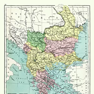
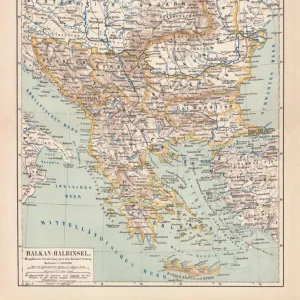
Balkan States, lithograph, published in 1878

![]()
Wall Art and Photo Gifts from Fine Art Storehouse
Balkan States, lithograph, published in 1878
Ancient map of the Balkan States: Romania, Bulgaria, Serbia and Montenegro. Lithograph, published in 1878
Unleash your creativity and transform your space into a visual masterpiece!
Media ID 13666793
© ZU_09
78279 Austria Austria Hungary Balkans Belgrade Serbia Black Sea Bucharest Bulgaria Bulgarian Culture Contour Drawing Country Geographic Area Ethnocultural History Hungary Image Date Land Romania Russia Serbia Serbia And Montenegro Sofia Topographic Map Topography Transylvania Image Created 19th Century Romanian Culture Sarajevo Timisoara
FEATURES IN THESE COLLECTIONS
> Europe
> Montenegro
> Maps
> Europe
> Romania
> Bucharest
> Fine Art Storehouse
> Map
> Historical Maps
EDITORS COMMENTS
This lithograph, published in 1878, takes us on a journey back in time to the Balkan States of Romania, Bulgaria, Serbia and Montenegro. The ancient map showcases the rich history and topography of this region that has witnessed countless cultural exchanges and historical events. As we gaze upon this engraved image created in the 19th century, our eyes are drawn to the intricate details that reveal the past. From Sarajevo to Transylvania, from Sofia to Bucharest, each capital city is marked with precision on this horizontal depiction. The land stretches from Russia to Hungary, encompassing Romania, Bulgaria, Serbia and Montenegro along its way. The Black Sea glistens at its eastern edge as a reminder of the importance of maritime trade routes throughout history. This antique print not only serves as a visual representation but also offers insights into ethnocultural histories and country geographic areas. It provides a glimpse into Romanian culture with Timisoara's presence while highlighting Austria-Hungary's influence through Belgrade's prominence. The contour drawing adds depth and dimensionality to this topographic map which can be appreciated even in modern times. Its preservation allows us to appreciate how these countries have evolved over centuries while still maintaining their unique identities within Europe. Whether you are an avid historian or simply fascinated by old-world charm captured through photography like this lithograph from 2015 (which itself pays homage to the original), it is impossible not to marvel at the beauty and significance encapsulated within this piece
MADE IN AUSTRALIA
Safe Shipping with 30 Day Money Back Guarantee
FREE PERSONALISATION*
We are proud to offer a range of customisation features including Personalised Captions, Color Filters and Picture Zoom Tools
SECURE PAYMENTS
We happily accept a wide range of payment options so you can pay for the things you need in the way that is most convenient for you
* Options may vary by product and licensing agreement. Zoomed Pictures can be adjusted in the Cart.