Framed Print > North America > United States of America > New York > New York > Maps
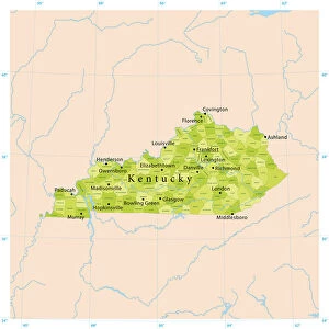
Framed Print : Map of Kentucky and Tennessee 1855


![]()
Framed Photos from Fine Art Storehouse
Map of Kentucky and Tennessee 1855
System of Geography for the use of schools by Sidney E. Morse - Published by Harper & Brothers - New York 1855
Unleash your creativity and transform your space into a visual masterpiece!
THEPALMER
Media ID 13668803
© Roberto A Sanchez
Backgrounds Direction Kentucky North America Paper Patina Sepia Toned Tennessee Textured Effect Obsolete Retro Styled
A2 Premium Frame with A3 Poster
Discover the rich history of the American South with our exquisite "Map of Kentucky and Tennessee 1855" Framed Print from Media Storehouse. This beautiful piece, featuring the detailed and intricate map by THEPALMER from the "System of Geography for the use of schools" published by Harper & Brothers in New York, takes you back in time. The antique map showcases the geography of Kentucky and Tennessee during this significant period in American history. With its authentic, aged look, this framed print makes a stunning addition to any home or office, transporting you to the past while adding a touch of timeless charm to your decor. Order yours today and bring a piece of history into your space.
Premium Paradise Wooden Range A2 Premium Poster Frame (62x45cm) with A3 Poster (42x30cm) and mounted behind a white matt board to make your photo really stand out. FSC Certified and Rainforest Alliance Certified for environmental, social, and economic sustainably. High transparency tempered glass window with a smooth finished frame. Great for filling empty walls, decorating blank spaces, or creating eye-catching gallery walls. Frames arrive ready to hang. Sent with secure, protective packaging. Smooth wooden veneer mimics the real wood look and feel with ultra-durable scratch resistance tempered glass.
Contemporary Framed and Mounted Prints - Professionally Made and Ready to Hang
Estimated Image Size (if not cropped) is 40.4cm x 40.4cm (15.9" x 15.9")
Estimated Product Size is 62cm x 44.6cm (24.4" x 17.6")
These are individually made so all sizes are approximate
Artwork printed orientated as per the preview above, with landscape (horizontal) or portrait (vertical) orientation to match the source image.
FEATURES IN THESE COLLECTIONS
> Fine Art Storehouse
> The Magical World of Illustration
> Palmer Illustrated Collection
> Fine Art Storehouse
> Map
> USA Maps
> Maps and Charts
> Related Images
> North America
> Related Images
> North America
> United States of America
> Kentucky
> Related Images
> North America
> United States of America
> Maps
> North America
> United States of America
> New York
> New York
> Maps
> North America
> United States of America
> New York
> Related Images
> North America
> United States of America
> Tennessee
> Related Images
EDITORS COMMENTS
This print showcases a vintage map of Kentucky and Tennessee from the year 1855. A relic from the past, this piece is reminiscent of a time when cartography was an art form in itself. The map, originally published by Harper & Brothers in New York, was part of Sidney E. Morse's "System of Geography for the use of schools". The retro styling adds to its charm, with sepia tones and textured effects giving it an aged appearance. The paper background further enhances its nostalgic appeal, evoking memories of old atlases and dusty libraries. As you gaze at this obsolete treasure, you can't help but appreciate the intricate details that were painstakingly crafted by hand. Every contour line and river course tells a story about the physical geography of these two states. The horizontal orientation allows for easy exploration as your eyes wander across names like Nashville and Louisville, tracing their paths on this historical document. The patina that has developed over time only adds to its allure, reminding us that even maps have stories to tell. Whether you're a history enthusiast or simply captivated by the beauty of old-world cartography, this illustration transports you back to a different era in North America's history. It serves as a reminder that while technology may have changed how we navigate our world today, there is still something magical about holding an intricately designed map in your hands - even if it's just through a print like this one by THEPALMER from Fine Art Storehouse.
MADE IN AUSTRALIA
Safe Shipping with 30 Day Money Back Guarantee
FREE PERSONALISATION*
We are proud to offer a range of customisation features including Personalised Captions, Color Filters and Picture Zoom Tools
SECURE PAYMENTS
We happily accept a wide range of payment options so you can pay for the things you need in the way that is most convenient for you
* Options may vary by product and licensing agreement. Zoomed Pictures can be adjusted in the Cart.