Photo Mug > North America > United States of America > New York > New York > Maps
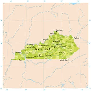
Photo Mug : Map of Kentucky and Tennessee 1855


![]()
Home Decor from Fine Art Storehouse
Map of Kentucky and Tennessee 1855
System of Geography for the use of schools by Sidney E. Morse - Published by Harper & Brothers - New York 1855
Unleash your creativity and transform your space into a visual masterpiece!
THEPALMER
Media ID 13668803
© Roberto A Sanchez
Backgrounds Direction Kentucky North America Paper Patina Sepia Toned Tennessee Textured Effect Obsolete Retro Styled
Photo Mug
Introducing the Media Storehouse Photo Mug featuring a captivating vintage map of Kentucky and Tennessee from 1855. This beautiful design, titled "Map of Kentucky and Tennessee" by THEPALMER from Fine Art Storehouse, is taken from the System of Geography for the use of schools by Sidney E. Morse, published by Harper & Brothers in New York. Bring a piece of history to your daily routine with this high-quality mug, perfect for sipping your favorite hot beverage and reminiscing about the past. Each mug is expertly printed with vibrant, fade-resistant ink to ensure your map stays clear and crisp, even after multiple uses. Order yours today and enjoy a unique blend of history and functionality.
A personalised photo mug blends sentimentality with functionality, making an ideal gift for cherished loved ones, close friends, or valued colleagues. Preview may show both sides of the same mug.
Elevate your coffee or tea experience with our premium white ceramic mug. Its wide, comfortable handle makes drinking easy, and you can rely on it to be both microwave and dishwasher safe. Sold in single units, preview may show both sides of the same mug so you can see how the picture wraps around.
Mug Size is 8.1cm high x 9.6cm diameter (3.2" x 3.8")
These are individually made so all sizes are approximate
FEATURES IN THESE COLLECTIONS
> Fine Art Storehouse
> The Magical World of Illustration
> Palmer Illustrated Collection
> Fine Art Storehouse
> Map
> USA Maps
> Maps and Charts
> Related Images
> North America
> Related Images
> North America
> United States of America
> Kentucky
> Related Images
> North America
> United States of America
> Maps
> North America
> United States of America
> New York
> New York
> Maps
> North America
> United States of America
> New York
> Related Images
> North America
> United States of America
> Tennessee
> Related Images
EDITORS COMMENTS
This print showcases a vintage map of Kentucky and Tennessee from the year 1855. A relic from the past, this piece is reminiscent of a time when cartography was an art form in itself. The map, originally published by Harper & Brothers in New York, was part of Sidney E. Morse's "System of Geography for the use of schools". The retro styling adds to its charm, with sepia tones and textured effects giving it an aged appearance. The paper background further enhances its nostalgic appeal, evoking memories of old atlases and dusty libraries. As you gaze at this obsolete treasure, you can't help but appreciate the intricate details that were painstakingly crafted by hand. Every contour line and river course tells a story about the physical geography of these two states. The horizontal orientation allows for easy exploration as your eyes wander across names like Nashville and Louisville, tracing their paths on this historical document. The patina that has developed over time only adds to its allure, reminding us that even maps have stories to tell. Whether you're a history enthusiast or simply captivated by the beauty of old-world cartography, this illustration transports you back to a different era in North America's history. It serves as a reminder that while technology may have changed how we navigate our world today, there is still something magical about holding an intricately designed map in your hands - even if it's just through a print like this one by THEPALMER from Fine Art Storehouse.
MADE IN AUSTRALIA
Safe Shipping with 30 Day Money Back Guarantee
FREE PERSONALISATION*
We are proud to offer a range of customisation features including Personalised Captions, Color Filters and Picture Zoom Tools
SECURE PAYMENTS
We happily accept a wide range of payment options so you can pay for the things you need in the way that is most convenient for you
* Options may vary by product and licensing agreement. Zoomed Pictures can be adjusted in the Cart.