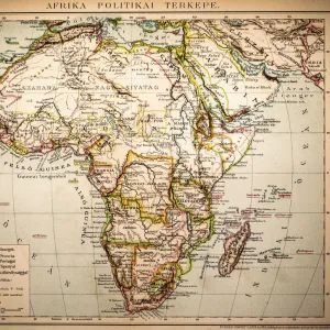
Framed Print : 1848, Levasseur Map of Senegal, Gambia and Madagascar, topography, cartography, geography


![]()
Framed Photos from Liszt Collection
1848, Levasseur Map of Senegal, Gambia and Madagascar, topography, cartography, geography
1848, Levasseur Map of Senegal, Gambia and Madagascar
Liszt Collection of nineteenth-century engravings and images to browse and enjoy
Media ID 14005144
© Artokoloro Quint Lox Limited
1848 Antique Map Latitude Longitude Mappa Mundi Old Antique Plan Old Antique View Ols Antique Map Rare Old Maps Topo
A2 Premium Frame with A3 Poster
Discover the rich history and geography of West Africa with our stunning framed print from the Media Storehouse Liszt Collection. This exquisite piece showcases the 1848 Levasseur Map of Senegal, Gambia, and Madagascar. The intricate topography and cartography details bring the past to life, making it an essential addition to any home or office decor. Impress your guests with this unique and educational art piece, expertly framed to preserve its beauty and authenticity for generations to come.
Premium Paradise Wooden Range A2 Premium Poster Frame (62x45cm) with A3 Poster (42x30cm) and mounted behind a white matt board to make your photo really stand out. FSC Certified and Rainforest Alliance Certified for environmental, social, and economic sustainably. High transparency tempered glass window with a smooth finished frame. Great for filling empty walls, decorating blank spaces, or creating eye-catching gallery walls. Frames arrive ready to hang. Sent with secure, protective packaging. Smooth wooden veneer mimics the real wood look and feel with ultra-durable scratch resistance tempered glass.
Contemporary Framed and Mounted Prints - Professionally Made and Ready to Hang
Estimated Image Size (if not cropped) is 40.4cm x 40.4cm (15.9" x 15.9")
Estimated Product Size is 62cm x 44.6cm (24.4" x 17.6")
These are individually made so all sizes are approximate
Artwork printed orientated as per the preview above, with landscape (horizontal) or portrait (vertical) orientation to match the source image.
EDITORS COMMENTS
This print showcases the exquisite "1848, Levasseur Map of Senegal, Gambia and Madagascar". A true masterpiece in topography, cartography, and geography, this vintage map takes us on a journey through time. The intricate details and precision of this ancient artifact allow us to explore these regions with unparalleled accuracy. The artist's skillful hand has beautifully illustrated the landforms and geographic features of Senegal, Gambia, and Madagascar. From the rolling hills to the meandering rivers, every contour is meticulously depicted. This map serves as a valuable resource for travelers seeking to navigate these lands or historians delving into their rich past. With its grid lines marking latitude and longitude coordinates like an elaborate geometric puzzle, this map becomes a window into history. Its presence evokes a sense of nostalgia for bygone eras when exploration was at its peak. As we gaze upon it today, we are reminded of the countless journeys embarked upon by brave adventurers who used maps like these as their guiding stars. This rare old map holds immense historical significance; it is not merely paper but rather a testament to human curiosity and discovery. Its decorative elements add an artistic touch that elevates it beyond mere navigation tool status. It stands as a reminder of our planet's vastness and diversity while also serving as an homage to those who paved the way for our understanding of the world.
MADE IN AUSTRALIA
Safe Shipping with 30 Day Money Back Guarantee
FREE PERSONALISATION*
We are proud to offer a range of customisation features including Personalised Captions, Color Filters and Picture Zoom Tools
SECURE PAYMENTS
We happily accept a wide range of payment options so you can pay for the things you need in the way that is most convenient for you
* Options may vary by product and licensing agreement. Zoomed Pictures can be adjusted in the Cart.