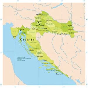
Framed Print : 1852, S. D. U. K. Pocket Map of the Balkans, Croatia, Dalmatia, Sclavonia, topography


![]()
Framed Photos from Liszt Collection
1852, S. D. U. K. Pocket Map of the Balkans, Croatia, Dalmatia, Sclavonia, topography
1852, S.D.U.K. Pocket Map of the Balkans, Croatia, Dalmatia, Sclavonia
Liszt Collection of nineteenth-century engravings and images to browse and enjoy
Media ID 14005362
© Artokoloro Quint Lox Limited
1852 Croatia Antique Map Dalmatia Latitude Longitude Mappa Mundi Old Antique Plan Old Antique View Ols Antique Map Rare Old Maps Topo
A2 Premium Frame with A3 Poster
Step back in time with our exquisite Framed Print from Media Storehouse's vintage map collection. This 1852 S.D.U.K. Pocket Map of the Balkans, Croatia, Dalmatia, Sclavonia, topography, hails from the esteemed Liszt Collection. Each detail of this antique map, meticulously framed, transports you back to a time of exploration and discovery. A striking addition to any room, this historical map print is not just a decorative piece, but also a conversation starter and a testament to the rich history of the Balkans region.
Premium Paradise Wooden Range A2 Premium Poster Frame (62x45cm) with A3 Poster (42x30cm) and mounted behind a white matt board to make your photo really stand out. FSC Certified and Rainforest Alliance Certified for environmental, social, and economic sustainably. High transparency tempered glass window with a smooth finished frame. Great for filling empty walls, decorating blank spaces, or creating eye-catching gallery walls. Frames arrive ready to hang. Sent with secure, protective packaging. Smooth wooden veneer mimics the real wood look and feel with ultra-durable scratch resistance tempered glass.
Contemporary Framed and Mounted Prints - Professionally Made and Ready to Hang
Estimated Image Size (if not cropped) is 40.4cm x 40.4cm (15.9" x 15.9")
Estimated Product Size is 62cm x 44.6cm (24.4" x 17.6")
These are individually made so all sizes are approximate
Artwork printed orientated as per the preview above, with landscape (horizontal) or portrait (vertical) orientation to match the source image.
EDITORS COMMENTS
This vintage print showcases the intricate beauty of the 1852 S. D. U. K. Pocket Map of the Balkans, Croatia, Dalmatia, and Sclavonia. With its detailed topography and cartographic precision, this map offers a fascinating glimpse into the geography and landforms of these regions during that era. The illustration captures a sense of historical significance as it transports us back to a time when exploration and discovery were at their peak. The carefully drawn grid lines denote latitude and longitude, providing an accurate representation of the area's geographic coordinates. As we admire this ancient artifact, we are reminded of how maps have played a crucial role in navigation throughout history. This decorative piece serves as both an art form and a practical tool for travelers seeking to explore unknown territories. The aged appearance adds to its charm, evoking nostalgia for bygone eras while preserving our connection with the past. It is indeed rare to come across such old antique maps that offer insight into forgotten worlds. Whether you are an avid collector or simply appreciate historical artifacts, this print from Liszt Collection is sure to pique your interest. Its rich history combined with its artistic appeal makes it a valuable addition to any collection or display space dedicated to exploring our world's diverse landscapes.
MADE IN AUSTRALIA
Safe Shipping with 30 Day Money Back Guarantee
FREE PERSONALISATION*
We are proud to offer a range of customisation features including Personalised Captions, Color Filters and Picture Zoom Tools
SECURE PAYMENTS
We happily accept a wide range of payment options so you can pay for the things you need in the way that is most convenient for you
* Options may vary by product and licensing agreement. Zoomed Pictures can be adjusted in the Cart.