Framed Print > Arts > Artists > S > John Speed
Framed Print : Dorset Historical John Speed 1610 Map


![]()
Framed Photos From Map Marketing
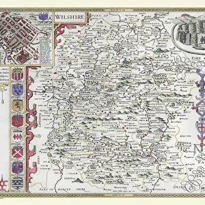
Dorset Historical John Speed 1610 Map
A reproduction of John Speeds historical map of the county of Dorset. Originally published as part of his atlas called The Theatre of the Empire of Great Britain in 1610. John Speed ((1552-1629) was a renowned English cartographer, his maps themselves were of high quality and gained a great reputation for being among the best county maps
Media ID 19949213
© Map Marketing Ltd
1610 Historical Map John Speed Dorsetshire
21.5"x17.5" (55x44cm) Premium Frame
Framed and mounted 17x12 print. Professionally handmade full timber moulded frames are finished off with framers tape and come with a hanging solution on the back. Outer dimensions are 21.5x17.5 inches (546x444mm). Quality timber frame frame moulding (20mm wide and 30mm deep) with frame colours in your choice of black, white, or raw oak and a choice of black or white card mounts. Frames have a perspex front providing a virtually unbreakable glass-like finish which is easily cleaned with a damp cloth.
Contemporary Framed and Mounted Prints - Professionally Made and Ready to Hang
Estimated Image Size (if not cropped) is 41.8cm x 41.8cm (16.5" x 16.5")
Estimated Product Size is 54.6cm x 44.4cm (21.5" x 17.5")
These are individually made so all sizes are approximate
Artwork printed orientated as per the preview above, with landscape (horizontal) or portrait (vertical) orientation to match the source image.
FEATURES IN THESE COLLECTIONS
> Arts
> Artists
> S
> John Speed
> Europe
> United Kingdom
> England
> Dorset
> Related Images
> Maps and Charts
> British Empire Maps
> Maps and Charts
> Early Maps
> Maps and Charts
> Related Images
MADE IN AUSTRALIA
Safe Shipping with 30 Day Money Back Guarantee
FREE PERSONALISATION*
We are proud to offer a range of customisation features including Personalised Captions, Color Filters and Picture Zoom Tools
SECURE PAYMENTS
We happily accept a wide range of payment options so you can pay for the things you need in the way that is most convenient for you
* Options may vary by product and licensing agreement. Zoomed Pictures can be adjusted in the Basket.