Framed Print > Maps and Charts > Related Images
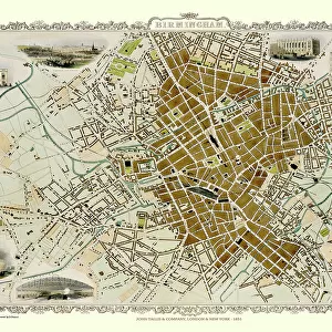
Framed Print : Old Map of Birmingham 1832 by James Drake


![]()
Framed Photos from MapSeeker
Old Map of Birmingham 1832 by James Drake
J069
Welcome to the Mapseeker Image library and enter an historic gateway to one of the largest on-line collections of Historic Maps, Nostalgic Views, Vista's and Panorama's from a World gone by.
Media ID 20347158
Birmingham Birmingham City Birmingham City Map Birmingham Map Birmingham Town Plan City Of Birmingham Map Historic Birmingham Map Historic Map Map Of Birmingham Old Map Of Birmingham Old Town Plan Town Plan Of Birmingham Drake
A2 Premium Frame with A3 Poster
Step back in time with our Old Map of Birmingham 1832 by James Drake (J069) Framed Print from Media Storehouse. This exquisite map, sourced from MapSeeker, offers a captivating glimpse into the history of Birmingham over 180 years ago. The intricate details of the map are beautifully preserved and presented in a contemporary frame, making it a perfect addition to any home or office. Bring a touch of history into your space with this unique and intriguing piece.
Premium Paradise Wooden Range A2 Premium Poster Frame (62x45cm) with A3 Poster (42x30cm) and mounted behind a white matt board to make your photo really stand out. FSC Certified and Rainforest Alliance Certified for environmental, social, and economic sustainably. High transparency tempered glass window with a smooth finished frame. Great for filling empty walls, decorating blank spaces, or creating eye-catching gallery walls. Frames arrive ready to hang. Sent with secure, protective packaging. Smooth wooden veneer mimics the real wood look and feel with ultra-durable scratch resistance tempered glass.
Contemporary Framed and Mounted Prints - Professionally Made and Ready to Hang
Estimated Image Size (if not cropped) is 40.4cm x 40.4cm (15.9" x 15.9")
Estimated Product Size is 62cm x 44.6cm (24.4" x 17.6")
These are individually made so all sizes are approximate
Artwork printed orientated as per the preview above, with landscape (horizontal) or portrait (vertical) orientation to match the source image.
FEATURES IN THESE COLLECTIONS
> Maps and Charts
> Related Images
> MapSeeker
> British Town And City Plans
> English & Welsh PORTFOLIO
EDITORS COMMENTS
This print showcases the "Old Map of Birmingham 1832" meticulously crafted by James Drake. A true testament to historical cartography, this map takes us back in time to the bustling city of Birmingham during its early years. With intricate details and precision, Drake's work offers a glimpse into the past, revealing the layout and structure of this vibrant town. As we delve into this piece, we are transported to a bygone era where horse-drawn carriages traversed cobblestone streets lined with charming buildings and shops. The map highlights key landmarks such as St. Philip's Cathedral, showcasing their grandeur even in those early days. The Old Map of Birmingham 1832 serves as a valuable resource for historians and enthusiasts alike, providing insights into urban development and growth over time. It allows us to appreciate how far this remarkable city has come while preserving its rich heritage. With its warm sepia tones and delicate aging marks, this print captures not only an important historical document but also evokes a sense of nostalgia for simpler times. Whether displayed in homes or offices, it invites viewers on an enchanting journey through Birmingham's past
MADE IN AUSTRALIA
Safe Shipping with 30 Day Money Back Guarantee
FREE PERSONALISATION*
We are proud to offer a range of customisation features including Personalised Captions, Color Filters and Picture Zoom Tools
SECURE PAYMENTS
We happily accept a wide range of payment options so you can pay for the things you need in the way that is most convenient for you
* Options may vary by product and licensing agreement. Zoomed Pictures can be adjusted in the Cart.