Framed Print > Arts > Artists > H > Jodocus Hondius
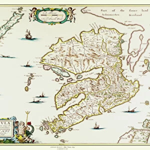
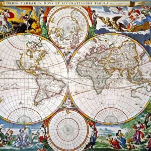
Framed Print : Old Map of The Island of Bermuda 1635 by Willem & Johan Blaue from the Theatrum Orbis Terrarum


![]()
Framed Photos from MapSeeker
Old Map of The Island of Bermuda 1635 by Willem & Johan Blaue from the Theatrum Orbis Terrarum
This detailed and most attractive reproduction map of The Island of Bermuda has been carefully art worked from a scan of an antique original. The famous firm of Dutch cartographers and publishers was established in the late 16th century by Willem Janszoon Blaeu in Amsterdam. Blaeu was a maker of globes and scientific instruments and purchased some of his early map plates from Jodocus Hondius. From this small beginning was to emerge one of the largest and most prolific map publishing houses of the seventeenth century
Welcome to the Mapseeker Image library and enter an historic gateway to one of the largest on-line collections of Historic Maps, Nostalgic Views, Vista's and Panorama's from a World gone by.
Media ID 20347697
Blaeu Blaeu Family Blaue Map Historic Map Johan Blaeu Johan Blaeu Map Old Blaue Map Bermuda
A2 Premium Frame with A3 Poster
Discover the rich history of Bermuda with our exquisite Framed Print of the Old Map of The Island of Bermuda, dated 1635. Meticulously reproduced from the original map published by Willem & Johan Blaue in Theatrum Orbis Terrarum, this captivating piece showcases intricate details of the island's early settlements, coastlines, and geographical features. Each print is carefully art-worked from a high-resolution scan, ensuring a stunningly accurate and vibrant representation of this historical treasure. Bring a piece of the past into your home or office with our Framed Print of the Old Map of Bermuda - a perfect addition for history enthusiasts, cartography collectors, or anyone who appreciates the beauty of antique maps.
Premium Paradise Wooden Range A2 Premium Poster Frame (62x45cm) with A3 Poster (42x30cm) and mounted behind a white matt board to make your photo really stand out. FSC Certified and Rainforest Alliance Certified for environmental, social, and economic sustainably. High transparency tempered glass window with a smooth finished frame. Great for filling empty walls, decorating blank spaces, or creating eye-catching gallery walls. Frames arrive ready to hang. Sent with secure, protective packaging. Smooth wooden veneer mimics the real wood look and feel with ultra-durable scratch resistance tempered glass.
Contemporary Framed and Mounted Prints - Professionally Made and Ready to Hang
Estimated Image Size (if not cropped) is 40.4cm x 40.4cm (15.9" x 15.9")
Estimated Product Size is 62cm x 44.6cm (24.4" x 17.6")
These are individually made so all sizes are approximate
Artwork printed orientated as per the preview above, with landscape (horizontal) or portrait (vertical) orientation to match the source image.
FEATURES IN THESE COLLECTIONS
> Arts
> Artists
> B
> Willem Blaeu
> Arts
> Artists
> H
> Jodocus Hondius
> Arts
> Photorealistic artworks
> Detailed art pieces
> Masterful detailing in art
> Maps and Charts
> Early Maps
> Maps and Charts
> Related Images
> Maps and Charts
> Willem Janszoon Blaeu
> North America
> Bermuda
> Maps
> North America
> Bermuda
> Related Images
> MapSeeker
> Maps of the Americas
> Maps of Central and South America
EDITORS COMMENTS
This beautifully crafted reproduction of the "Old Map of The Island of Bermuda 1635" by Willem & Johan Blaue takes us back in time to explore the rich history and captivating beauty of this enchanting island. Carefully art worked from a scan of an antique original, this detailed map showcases the expertise and skill of the famous Dutch cartographers and publishers. Established in Amsterdam during the late 16th century by Willem Janszoon Blaeu, who was renowned for his globes and scientific instruments, this iconic firm grew to become one of the largest and most prolific map publishing houses of the seventeenth century. This particular map is a testament to their dedication to accuracy and aesthetics. As we delve into its intricate details, we are transported to a time when Bermuda was known as Isle de Demonstration on maps. From its stunning coastline dotted with coral reefs to its lush interior filled with verdant landscapes, every aspect is meticulously depicted. The historical significance attached to this old Bermuda map adds another layer of fascination. It serves as a window into how early explorers perceived and documented these uncharted territories. Whether you're an avid historian or simply captivated by vintage cartography, this reproduction offers a glimpse into both past eras and distant lands. Display it proudly as a conversation starter or use it as inspiration for your own adventures on the remarkable Island of Bermuda.
MADE IN AUSTRALIA
Safe Shipping with 30 Day Money Back Guarantee
FREE PERSONALISATION*
We are proud to offer a range of customisation features including Personalised Captions, Color Filters and Picture Zoom Tools
SECURE PAYMENTS
We happily accept a wide range of payment options so you can pay for the things you need in the way that is most convenient for you
* Options may vary by product and licensing agreement. Zoomed Pictures can be adjusted in the Cart.