Framed Print > Europe > United Kingdom > England > London > Sights > British Museum
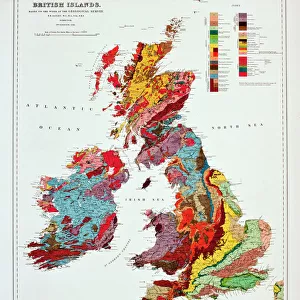
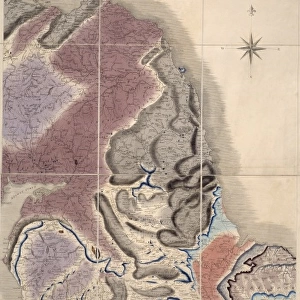
Framed Print : Geological map of Britain and Ireland


![]()
Framed Photos from Mary Evans Picture Library
Geological map of Britain and Ireland
Fig 9 from Britain Before Man (1978), a Geological Museum publication
Mary Evans Picture Library makes available wonderful images created for people to enjoy over the centuries
Media ID 8613371
© Mary Evans Picture Library 2015 - https://copyrighthub.org/s0/hub1/creation/maryevans/MaryEvansPictureID/10706165
Before Geological Geology Great Britain United Kingdom
13.5"x11.5" (34x29cm) Premium Frame
Discover the rich geological history of Britain and Ireland with our stunning Framed Print from the Media Storehouse collection. This captivating piece showcases Fig 9 from Britain Before Man (1978), a publication of the Geological Museum. Featuring the "Geological map of Britain and Ireland" by Rights Managed from Mary Evans Prints Online, this print is a must-have for geology enthusiasts and those who appreciate the wonders of the natural world. The high-quality print is expertly framed to preserve its vibrant colors and intricate details, making it a beautiful addition to any home or office. Delve into the fascinating story of the land beneath our feet with this exquisite Framed Print.
Framed and mounted 9x7 print. Professionally handmade full timber moulded frames are finished off with framers tape and come with a hanging solution on the back. Outer dimensions are 13.5x11.5 inches (34x29cm). Quality timber frame frame moulding (20mm wide and 30mm deep) with frame colours in your choice of black, white, or raw oak and a choice of black or white card mounts. Frames have a perspex front providing a virtually unbreakable glass-like finish which is easily cleaned with a damp cloth.
Contemporary Framed and Mounted Prints - Professionally Made and Ready to Hang
Estimated Image Size (if not cropped) is 21.4cm x 21.4cm (8.4" x 8.4")
Estimated Product Size is 34cm x 29.2cm (13.4" x 11.5")
These are individually made so all sizes are approximate
Artwork printed orientated as per the preview above, with landscape (horizontal) or portrait (vertical) orientation to match the source image.
FEATURES IN THESE COLLECTIONS
> Europe
> Related Images
> Europe
> Republic of Ireland
> Maps
> Europe
> United Kingdom
> England
> London
> Sights
> British Museum
> Europe
> United Kingdom
> Related Images
> Maps and Charts
> Geological Map
> Maps and Charts
> Related Images
MADE IN AUSTRALIA
Safe Shipping with 30 Day Money Back Guarantee
FREE PERSONALISATION*
We are proud to offer a range of customisation features including Personalised Captions, Color Filters and Picture Zoom Tools
SECURE PAYMENTS
We happily accept a wide range of payment options so you can pay for the things you need in the way that is most convenient for you
* Options may vary by product and licensing agreement. Zoomed Pictures can be adjusted in the Cart.