Photo Mug > Europe > United Kingdom > England > London > Sights > British Museum
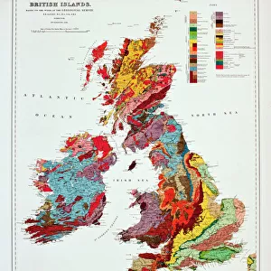
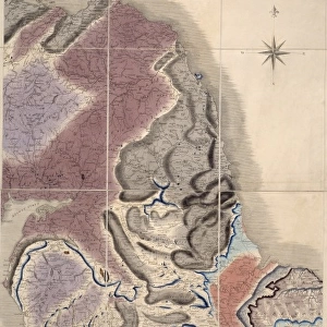
Photo Mug : Geological map of Britain and Ireland


![]()
Home Decor from Mary Evans Picture Library
Geological map of Britain and Ireland
Fig 9 from Britain Before Man (1978), a Geological Museum publication
Mary Evans Picture Library makes available wonderful images created for people to enjoy over the centuries
Media ID 8613371
© Mary Evans Picture Library 2015 - https://copyrighthub.org/s0/hub1/creation/maryevans/MaryEvansPictureID/10706165
Before Geological Geology Great Britain United Kingdom
Photo Mug
Discover the wonders of geology with every sip from our Media Storehouse Photo Mug featuring a captivating image of the "Geological map of Britain and Ireland" (Fig 9 from Britain Before Man, 1978). This beautifully designed mug showcases intricate details of the geological formations across the British Isles, making it an ideal gift for geologists, educators, or anyone with a passion for the natural world. Made of high-quality ceramic material, this mug not only retains heat effectively but also adds a touch of sophistication to your daily routine. Enjoy your favorite beverage while immersing yourself in the fascinating world of geology, all in one convenient and stylish package.
A personalised photo mug blends sentimentality with functionality, making an ideal gift for cherished loved ones, close friends, or valued colleagues. Preview may show both sides of the same mug.
Elevate your coffee or tea experience with our premium white ceramic mug. Its wide, comfortable handle makes drinking easy, and you can rely on it to be both microwave and dishwasher safe. Sold in single units, preview may show both sides of the same mug so you can see how the picture wraps around.
Mug Size is 8.1cm high x 9.6cm diameter (3.2" x 3.8")
These are individually made so all sizes are approximate
FEATURES IN THESE COLLECTIONS
> Europe
> Related Images
> Europe
> Republic of Ireland
> Maps
> Europe
> United Kingdom
> England
> London
> Sights
> British Museum
> Europe
> United Kingdom
> Related Images
> Maps and Charts
> Geological Map
> Maps and Charts
> Related Images
EDITORS COMMENTS
1. Title: "Geological Map of Britain and Ireland: A Snapshot of the Geological History of the British Isles" Fig. 9, from the prestigious publication "Britain Before Man" (1978) by the Geological Museum, offers a captivating glimpse into the geological makeup of Britain and Ireland. This exquisitely detailed geological map is a testament to the rich and complex history that lies beneath the surface of these two European nations. The intricate design of the map reveals the various rock types and formations that span millions of years, from the oldest Precambrian rocks to the youngest Quaternary deposits. The map's colorful key, located in the lower right corner, deciphers the different rock types, ranging from igneous and metamorphic to sedimentary formations. The British Isles' geological history is a fascinating tapestry of continental collisions, volcanic activity, and sedimentation processes. This map serves as an essential tool for geologists, archaeologists, and researchers, providing valuable insights into the geological events that have shaped the landscapes and cultures of Britain and Ireland. Moreover, the map offers a captivating visual representation of the Earth's history, revealing the intricate connections between geology and human history. The geological events depicted in the map have influenced the availability of natural resources, climate patterns, and the emergence of distinct ecosystems, all of which have played a crucial role in the development of human societies in the region. In summary, Fig. 9 from "Britain Before Man" is more than just a geological map; it is a visual narrative of the British Isles' geological history, a story that spans millions of years and continues to unfold. This stunning illustration is a must-see for anyone with an interest in geology, history, or the natural world.
MADE IN AUSTRALIA
Safe Shipping with 30 Day Money Back Guarantee
FREE PERSONALISATION*
We are proud to offer a range of customisation features including Personalised Captions, Color Filters and Picture Zoom Tools
SECURE PAYMENTS
We happily accept a wide range of payment options so you can pay for the things you need in the way that is most convenient for you
* Options may vary by product and licensing agreement. Zoomed Pictures can be adjusted in the Cart.