Framed Print > Maps and Charts > Early Maps
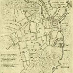
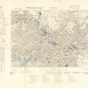
Framed Print : City of Sheffield Central Planning Scheme, Historical Growth, 1938


![]()
Framed Photos from Sheffield City Archives
City of Sheffield Central Planning Scheme, Historical Growth, 1938
Shows how Sheffield developed from 1736 onwards.Published by Sheffield City Council, Town Planning CommitteeScale: 208.33 feet : 1 inch.Size: 52 x 45 cm.Original at Sheffield Local Studies Library:s 16 M
Sheffield City Archives and Local Studies Library has an unrivalled collection of images of Sheffield, England
Media ID 14088680
© Sheffield City Council
13.5"x11.5" (34x29cm) Premium Frame
Step back in time and explore the rich history of Sheffield with our stunning Framed Print from Media Storehouse, featuring the "City of Sheffield Central Planning Scheme, Historical Growth, 1938." This captivating image, published by Sheffield City Council, Town Planning Committee, offers a unique perspective on the city's development from 1736 onwards. The intricate details of this scale map, originally housed at Sheffield Local Studies Library, will transport you back in time and make a beautiful addition to any home or office. Own a piece of Sheffield's history and order your Framed Print today!
Framed and mounted 9x7 print. Professionally handmade full timber moulded frames are finished off with framers tape and come with a hanging solution on the back. Outer dimensions are 13.5x11.5 inches (34x29cm). Quality timber frame frame moulding (20mm wide and 30mm deep) with frame colours in your choice of black, white, or raw oak and a choice of black or white card mounts. Frames have a perspex front providing a virtually unbreakable glass-like finish which is easily cleaned with a damp cloth.
Contemporary Framed and Mounted Prints - Professionally Made and Ready to Hang
Estimated Image Size (if not cropped) is 21.4cm x 21.4cm (8.4" x 8.4")
Estimated Product Size is 29.2cm x 34cm (11.5" x 13.4")
These are individually made so all sizes are approximate
Artwork printed orientated as per the preview above, with landscape (horizontal) or portrait (vertical) orientation to match the source image.
FEATURES IN THESE COLLECTIONS
> Maps and Charts
> Early Maps
> Maps and Charts
> Related Images
> Sheffield City Archives
> Maps and Plans
> Maps of Sheffield
> Sheffield City Archives
> Maps and Plans
EDITORS COMMENTS
This print showcases the City of Sheffield Central Planning Scheme, providing a fascinating glimpse into the historical growth of this vibrant city. Published by the esteemed Sheffield City Council's Town Planning Committee in 1938, this meticulously detailed map reveals how Sheffield has evolved since its humble beginnings in 1736. Measuring an impressive 52 x 45 cm, this remarkable piece offers an intricate depiction of Sheffield's urban development over the centuries. With a scale of 208.33 feet to one inch, every street and landmark is intricately illustrated, allowing viewers to trace the city's transformation from its early days to its bustling present. Preserved within the archives of Sheffield Local Studies Library under reference s16 M, this original document serves as a valuable resource for historians and enthusiasts alike. Its significance lies not only in capturing the physical expansion of Sheffield but also in shedding light on how urban planning shaped its layout and character. While it is important to note that commercial use should be avoided with regards to this image, it remains an invaluable tool for educational purposes or personal exploration. Whether you are interested in tracing your family roots or simply curious about how cities evolve over time, this print provides a unique window into Sheffield's rich history and ongoing development as a thriving metropolis at the heart of England.
MADE IN AUSTRALIA
Safe Shipping with 30 Day Money Back Guarantee
FREE PERSONALISATION*
We are proud to offer a range of customisation features including Personalised Captions, Color Filters and Picture Zoom Tools
SECURE PAYMENTS
We happily accept a wide range of payment options so you can pay for the things you need in the way that is most convenient for you
* Options may vary by product and licensing agreement. Zoomed Pictures can be adjusted in the Cart.