Jigsaw Puzzle > Maps and Charts > Early Maps
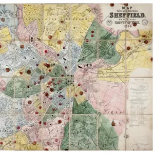
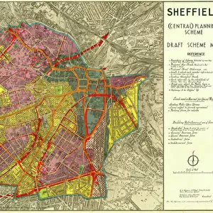
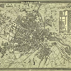
Jigsaw Puzzle : City of Sheffield Central Planning Scheme, Historical Growth, 1938


![]()
Jigsaw Puzzles from Sheffield City Archives
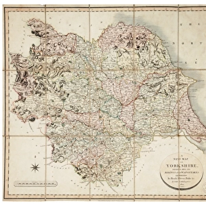
City of Sheffield Central Planning Scheme, Historical Growth, 1938
Shows how Sheffield developed from 1736 onwards.Published by Sheffield City Council, Town Planning CommitteeScale: 208.33 feet : 1 inch.Size: 52 x 45 cm.Original at Sheffield Local Studies Library:s 16 M
Sheffield City Archives and Local Studies Library has an unrivalled collection of images of Sheffield, England
Media ID 14088680
© Sheffield City Council
Jigsaw Puzzle (500 Pieces)
Discover the rich history of Sheffield with our Media Storehouse Jigsaw Puzzle featuring the City of Sheffield Central Planning Scheme, Historical Growth, 1736-1938. This intriguing puzzle, published by Sheffield City Council, Town Planning Committee, showcases the development of Sheffield over two centuries. The image, originally housed at Sheffield Local Studies Library, provides a unique perspective on urban planning and growth in this historic English city. With a stunning level of detail, this 52 x 45 cm puzzle is an engaging and educational activity for all ages. Piece together the past and bring Sheffield's fascinating history to life.
500 piece puzzles are custom made in Australia and hand-finished on 100% recycled 1.6mm thick laminated puzzle boards. There is a level of repetition in jigsaw shapes with each matching piece away from its pair. The completed puzzle measures 40x51cm and is delivered packaged in an attractive presentation box specially designed to fit most mail slots with a unique magnetic lid
Jigsaw Puzzles are an ideal gift for any occasion
Estimated Product Size is 40.3cm x 50.7cm (15.9" x 20")
These are individually made so all sizes are approximate
Artwork printed orientated as per the preview above, with landscape (horizontal) or portrait (vertical) orientation to match the source image.
FEATURES IN THESE COLLECTIONS
> Maps and Charts
> Early Maps
> Maps and Charts
> Related Images
> Sheffield City Archives
> Maps and Plans
> Maps of Sheffield
> Sheffield City Archives
> Maps and Plans
EDITORS COMMENTS
This print showcases the City of Sheffield Central Planning Scheme, providing a fascinating glimpse into the historical growth of this vibrant city. Published by the esteemed Sheffield City Council's Town Planning Committee in 1938, this meticulously detailed map reveals how Sheffield has evolved since its humble beginnings in 1736. Measuring an impressive 52 x 45 cm, this remarkable piece offers an intricate depiction of Sheffield's urban development over the centuries. With a scale of 208.33 feet to one inch, every street and landmark is intricately illustrated, allowing viewers to trace the city's transformation from its early days to its bustling present. Preserved within the archives of Sheffield Local Studies Library under reference s16 M, this original document serves as a valuable resource for historians and enthusiasts alike. Its significance lies not only in capturing the physical expansion of Sheffield but also in shedding light on how urban planning shaped its layout and character. While it is important to note that commercial use should be avoided with regards to this image, it remains an invaluable tool for educational purposes or personal exploration. Whether you are interested in tracing your family roots or simply curious about how cities evolve over time, this print provides a unique window into Sheffield's rich history and ongoing development as a thriving metropolis at the heart of England.
MADE IN AUSTRALIA
Safe Shipping with 30 Day Money Back Guarantee
FREE PERSONALISATION*
We are proud to offer a range of customisation features including Personalised Captions, Color Filters and Picture Zoom Tools
SECURE PAYMENTS
We happily accept a wide range of payment options so you can pay for the things you need in the way that is most convenient for you
* Options may vary by product and licensing agreement. Zoomed Pictures can be adjusted in the Cart.