Framed Print > Europe > France > Canton > Landes
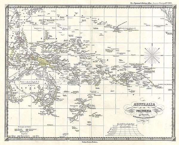
Framed Print : 1855 Spruner Map Of Australia And Polynesia With An Overview Of Discoveries And Colonization
![]()

Framed Photos from Universal Images Group (UIG)
1855 Spruner Map Of Australia And Polynesia With An Overview Of Discoveries And Colonization
1855, Spruner Map of Australia and Polynesia with an overview of Discoveries and Colonization
Universal Images Group (UIG) manages distribution for many leading specialist agencies worldwide
Media ID 38551338
© Artokoloro Quint Lox Limited
1855 Antique Map Latitude Longitude Mappa Mundi Old Antique Plan Old Antique View Ols Antique Map Rare Old Maps Topo
13.5"x11.5" (34x29cm) Premium Frame
"Step back in time with our Framed Prints from the Media Storehouse range, featuring historic maps that tell a story of discovery and exploration. This stunning print showcases the 1855 Spruner Map of Australia and Polynesia, highlighting key discoveries and colonization milestones. A beautiful piece for any history buff or map enthusiast, this framed print is sure to be a conversation starter in any room.
Framed and mounted 9x7 print. Professionally handmade full timber moulded frames are finished off with framers tape and come with a hanging solution on the back. Outer dimensions are 13.5x11.5 inches (34x29cm). Quality timber frame frame moulding (20mm wide and 30mm deep) with frame colours in your choice of black, white, or raw oak and a choice of black or white card mounts. Frames have a perspex front providing a virtually unbreakable glass-like finish which is easily cleaned with a damp cloth.
Contemporary Framed and Mounted Prints - Professionally Made and Ready to Hang
Estimated Image Size (if not cropped) is 21.4cm x 21.4cm (8.4" x 8.4")
Estimated Product Size is 34cm x 29.2cm (13.4" x 11.5")
These are individually made so all sizes are approximate
Artwork printed orientated as per the preview above, with landscape (horizontal) or portrait (vertical) orientation to match the source image.
FEATURES IN THESE COLLECTIONS
> Animals
> Fishes
> G
> Grouper
> Europe
> France
> Canton
> Landes
> Historic
> Space exploration
> Maps and Charts
> Early Maps
> Maps and Charts
> Related Images
> Maps and Charts
> World
> Universal Images Group (UIG)
> History
> Historical Maps
EDITORS COMMENTS
Step back in time to the mid-19th century with this stunning 1855 Spruner Map of Australia and Polynesia, a beautifully rendered illustration that showcases the vast expanse of these Pacific regions. This vintage map is not only a testament to the cartographic skills of its creator, but also a window into the era's understanding of geography, colonization, and exploration.
The intricate details on this map reveal the extent of European discovery and settlement in Australia and Polynesia during this period. The islands are depicted with remarkable accuracy, showcasing their unique topography and geographical features. The map also highlights key landmarks such as rivers, mountains, and coastal routes.
This historic map serves as a poignant reminder of humanity's enduring fascination with exploration and discovery. It captures a moment in time when European powers were expanding their colonial empires across the globe, shaping the course of history for centuries to come.
Today, this beautiful print remains an important piece of historical cartography, offering a glimpse into our collective past while inspiring future generations to continue exploring and mapping our world.
MADE IN AUSTRALIA
Safe Shipping with 30 Day Money Back Guarantee
FREE PERSONALISATION*
We are proud to offer a range of customisation features including Personalised Captions, Color Filters and Picture Zoom Tools
SECURE PAYMENTS
We happily accept a wide range of payment options so you can pay for the things you need in the way that is most convenient for you
* Options may vary by product and licensing agreement. Zoomed Pictures can be adjusted in the Cart.


