Fraud Blocker Skip to main content

Boundaries Collection (page 2)

"Exploring Boundaries: Tracing the Historical Imprints of Scotland's Borders" This captivating satellite image showcases the intricate boundaries that define Scotland

Background imageBoundaries Collection: A trip to Tuy and Valenca, on the boundaries of Portugal and Spain (litho)

A trip to Tuy and Valenca, on the boundaries of Portugal and Spain (litho)
1064386 A trip to Tuy and Valenca, on the boundaries of Portugal and Spain (litho) by Lanos, Henri (1859-1929); Private Collection; (add.info.: A trip to Tuy and Valenca)

Background imageBoundaries Collection: Viceroy of India, Lord Mountbatten reading the Kings Message in the presence of Muhammad Ali

Viceroy of India, Lord Mountbatten reading the Kings Message in the presence of Muhammad Ali Jinnah, 1947 (b / w photo)
1113936 Viceroy of India, Lord Mountbatten reading the Kings Message in the presence of Muhammad Ali Jinnah, 1947 (b/w photo) by English School

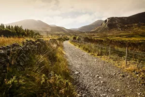
Background imageBoundaries Collection: Brandy Pad, Mourne Wall, Spellack, County Down, Ireland

Brandy Pad, Mourne Wall, Spellack, County Down, Ireland
A gravel trail leads through a mountainous landscape at sunrise, Brandy Pad, Mourne Wall, Spellack, County Down, Ireland

Background imageBoundaries Collection: crossing borders

crossing borders
Ina Tänzer

Background imageBoundaries Collection: Chart of the Coasts, Sindh and Cutch, Surveyed by Lieutenant A. M

Chart of the Coasts, Sindh and Cutch, Surveyed by Lieutenant A. M
XCF291080 Chart of the Coasts, Sindh and Cutch, Surveyed by Lieutenant A. M. Grieve, 1848-50, 1868 (colour litho) by English School, (19th century); Private Collection; English, out of copyright

Background imageBoundaries Collection: Caricature of the Congress of Vienna 1814-15 (colour litho)

Caricature of the Congress of Vienna 1814-15 (colour litho)
CHT211432 Caricature of the Congress of Vienna 1814-15 (colour litho) by Delaunois (fl.1815); Bibliotheque des Arts Decoratifs, Paris

Background imageBoundaries Collection: Map of the Roman, Macedonian, Persian and Assyrian Empires

Map of the Roman, Macedonian, Persian and Assyrian Empires
Map of the world showing the boundaries of the Roman, Macedonian, Persian and Assyrian Empires. Handcoloured copperplate engraving by Andrea Bernieri from Giulio Ferrarios Ancient

Background imageBoundaries Collection: Beating the bounds of the Tower of London 1906

Beating the bounds of the Tower of London 1906
Beating the bounds is still carried out in the Tower of London today every three years on Ascension Day. One of Londons oddest traditions
Background imageBoundaries Collection: Map of Boundaries of the Fire Department of the City of New York

Map of Boundaries of the Fire Department of the City of New York
1079261 Map of Boundaries of the Fire Department of the City of New York. 1871 (black and colour ink on paper backed with paper.) by American School

Background imageBoundaries Collection: Map of Yorkshire, engraved by William Web, published 1645 (engraving)

Map of Yorkshire, engraved by William Web, published 1645 (engraving)
STC222033 Map of Yorkshire, engraved by William Web, published 1645 (engraving) by Saxton, Christopher (1543-c.1610) (after); Private Collection; (add.info)

Background imageBoundaries Collection: Beating the bounds (engraving)

Beating the bounds (engraving)
5231011 Beating the bounds (engraving) by English School, (19th century); Private Collection; (add.info.: Beating the bounds)

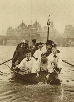
Background imageBoundaries Collection: Choristers of St Clement Danes beating the boundaries of their parish (b / w photo)

Choristers of St Clement Danes beating the boundaries of their parish (b / w photo)
3637342 Choristers of St Clement Danes beating the boundaries of their parish (b/w photo) by English Photographer, (20th century); Private Collection; (add.info)

Background imageBoundaries Collection: Choristers of St Clement Danes beating the boundaries of their parish (b / w photo)

Choristers of St Clement Danes beating the boundaries of their parish (b / w photo)
3637341 Choristers of St Clement Danes beating the boundaries of their parish (b/w photo) by English Photographer, (20th century); Private Collection; (add.info)

Background imageBoundaries Collection: Detail of a Map of the India-Tibet border, 1898 (colour litho)

Detail of a Map of the India-Tibet border, 1898 (colour litho)
XCF306011 Detail of a Map of the India-Tibet border, 1898 (colour litho) by English School, (19th century); Private Collection; English, out of copyright

Background imageBoundaries Collection: A British and American Boundary (b / w photo)

A British and American Boundary (b / w photo)
1042832 A British and American Boundary (b/w photo) by English photographer, (19th century) (after); Private Collection; (add.info.: A British and American Boundary)

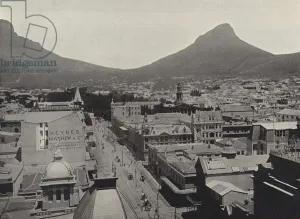
Background imageBoundaries Collection: View of Lions Head from Tower of Post Office (b / w photo)

View of Lions Head from Tower of Post Office (b / w photo)
3092302 View of Lions Head from Tower of Post Office (b/w photo) by English Photographer, (19th century); Private Collection; (add.info.: View of Lions Head from Tower of Post Office)

Background imageBoundaries Collection: Map of French territories under tax, 1709, from 'Le Theatre du Monde'

Map of French territories under tax, 1709, from "Le Theatre du Monde"
LRI3518462 Map of French territories under tax, 1709, from " Le Theatre du Monde" by Jean-Baptiste Nolin, published 1717 (hand-coloured engraving) by French School

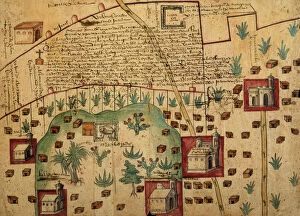
Background imageBoundaries Collection: Ayer MS 1801 Map 1: Map of lands in the Tultepec and Jaltocan regions adjacent to

Ayer MS 1801 Map 1: Map of lands in the Tultepec and Jaltocan regions adjacent to
NBY259416 Ayer MS 1801 Map 1: Map of lands in the Tultepec and Jaltocan regions adjacent to the Hacienda de Santa Ines, Mexico, published 1569 (colour litho) by Spanish School

Background imageBoundaries Collection: Map depicting North America as Divided by the European Powers, 1774 (litho)

Map depicting North America as Divided by the European Powers, 1774 (litho)
AQS256873 Map depicting North America as Divided by the European Powers, 1774 (litho) by American School, (18th century); American Antiquarian Society, Worcester, Massachusetts, USA; eCourtesy

Background imageBoundaries Collection: Index Chart of the Cutch Topographical Survey by the Trigonometrical Branch

Index Chart of the Cutch Topographical Survey by the Trigonometrical Branch
XCF306008 Index Chart of the Cutch Topographical Survey by the Trigonometrical Branch, Survey of India, Dehra Dun, November, 1884 (colour litho) by English School

Background imageBoundaries Collection: Constantine tracing the boundaries of the new capital

Constantine tracing the boundaries of the new capital
908873 Constantine tracing the boundaries of the new capital by Valda, John Harris (d.1941); (add.info.: Hutchinsons History of the Nations published Hutchinson & Co circa 1920); English

Background imageBoundaries Collection: The San Juan Boundary Question (engraving)

The San Juan Boundary Question (engraving)
1058171 The San Juan Boundary Question (engraving) by English School, (19th century); Private Collection; (add.info.: The San Juan Boundary Question)

Background imageBoundaries Collection: Peasants celebrating Christmas Eve at Tonniens 1854

Peasants celebrating Christmas Eve at Tonniens 1854
Old Christian custom on Christmas Eve, in France Germany and Norway, were farmers and peasants perambulating the fields, going round and round the boundary

Background imageBoundaries Collection: PORTRAIT OF A MAN BLOWING A CONCH SHELL AT THE SAN JAO FESTIVAL CELEBRATIONS, SIOLIM, GOA

PORTRAIT OF A MAN BLOWING A CONCH SHELL AT THE SAN JAO FESTIVAL CELEBRATIONS, SIOLIM, GOA
India, Goa, Sillim, San Jao Festival celebrated flower head wreaths, man blowing conch shell

Background imageBoundaries Collection: PORTRAIT OF SAN JAO FESTIVAL CELEBRATIONS, SIOLIM, GOA

PORTRAIT OF SAN JAO FESTIVAL CELEBRATIONS, SIOLIM, GOA
India, Goa, Siolim, San Jao Festival celebrated with flower head wreaths

Background imageBoundaries Collection: Fire Eating Tribals, Sarawak

Fire Eating Tribals, Sarawak
Singapore, Fire Eating performance by tribal people from Sarawak

Background imageBoundaries Collection: Scottish Borders TD8 6 Map

Scottish Borders TD8 6 Map
Postcode Sector Map of Scottish Borders TD8 6

Background imageBoundaries Collection: Geological Map of the Cutch Desert, 1870 (colour litho)

Geological Map of the Cutch Desert, 1870 (colour litho)
XCF306006 Geological Map of the Cutch Desert, 1870 (colour litho) by English School, (19th century); Private Collection; English, out of copyright

Background imageBoundaries Collection: Geological Map of the Kutch region of India, Geological Survey of India 1868-69

Geological Map of the Kutch region of India, Geological Survey of India 1868-69
XCF306004 Geological Map of the Kutch region of India, Geological Survey of India 1868-69 (colour litho) by English School, (19th century); Private Collection; English, out of copyright

Background imageBoundaries Collection: Map of India, published under the direction of Colonel H

Map of India, published under the direction of Colonel H
XCF306003 Map of India, published under the direction of Colonel H.R. Thuillier, R.E. Surveyor General of India, 1877 (colour litho) by English School, (19th century); Private Collection; English

Background imageBoundaries Collection: 16th century, antique, archival, barbarie coast, barbary coast, battles, borders

16th century, antique, archival, barbarie coast, barbary coast, battles, borders, boundaries, cartography, depicted, depicting, depiction, geography, historic, map, nobody, northern africa, ocean

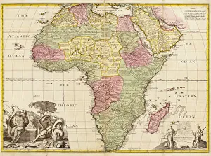
Background imageBoundaries Collection: Africa circa 1725 from Modern Geography

Africa circa 1725 from Modern Geography. Drawn and engraved by John Senex. The map shows boundaries of kingdoms and tribal areas on the continent as they were assumed to be in the early 18th century

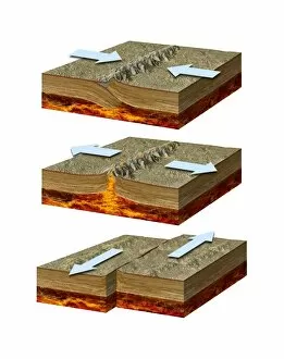
Background imageBoundaries Collection: Tectonic plate boundary types, diagram

Tectonic plate boundary types, diagram
Tectonic plate boundary types. Diagram showing three types of movement (arrows) at tectonic plate boundaries. Tectonic plates moving parallel to each other (bottom)

Background imageBoundaries Collection: Wet lane in the countryside in autumn, Richmond, North Yorkshire, England

Wet lane in the countryside in autumn, Richmond, North Yorkshire, England
Wet lane in the countryside in autumn with vibrant coloured foliage on the trees; Richmond, North Yorkshire, England

Background imageBoundaries Collection: Archival colour postcard on Great Wall, Nankow, China, circa 1915

Archival colour postcard on Great Wall, Nankow, China, circa 1915; Nankow, China

Background imageBoundaries Collection: Close-up of a stone wall of an abandoned church with storm clouds on the Isle of Skye in Scotland

Close-up of a stone wall of an abandoned church with storm clouds on the Isle of Skye in Scotland, United Kingdom

Background imageBoundaries Collection: Cattle Gate with Sun in the Summer, Seddon, Marlborough, South Island, New Zealand

Cattle Gate with Sun in the Summer, Seddon, Marlborough, South Island, New Zealand

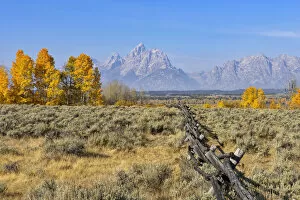
Background imageBoundaries Collection: Buck and rail fence with Teton Mountain Range in background, Jackson, Grand Teton

Buck and rail fence with Teton Mountain Range in background, Jackson, Grand Teton, Grand Teton National Park, Wyoming, USA

Background imageBoundaries Collection: Sand Fence at Beach near Cadiz, Costa De La Luz, Cadiz Province, Andalusia, Spain

Sand Fence at Beach near Cadiz, Costa De La Luz, Cadiz Province, Andalusia, Spain

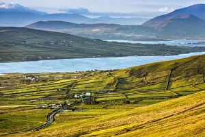
Background imageBoundaries Collection: Scenic overview of farmland with cows grazing in field, near Dingle, County Kerry, Ireland

Scenic overview of farmland with cows grazing in field, near Dingle, County Kerry, Ireland

Background imageBoundaries Collection: Scenic overview of farmland near Dingle, County Kerry, Ireland

Scenic overview of farmland near Dingle, County Kerry, Ireland

Background imageBoundaries Collection: Scenic, coastal view, Portmagee, along the Skellig Coast on the Ring of Kerry, County Kerry, Ireland

Scenic, coastal view, Portmagee, along the Skellig Coast on the Ring of Kerry, County Kerry, Ireland

Background imageBoundaries Collection: Scenic, coastal view of Caherdaniel, along the Ring of Kerry, County Kerry, Ireland

Scenic, coastal view of Caherdaniel, along the Ring of Kerry, County Kerry, Ireland

Background imageBoundaries Collection: Scenic view of fields and mountains along the Ring of Kerry, County Kerry, Ireland

Scenic view of fields and mountains along the Ring of Kerry, County Kerry, Ireland

Background imageBoundaries Collection: Scenic overview of farmland, Portmagee, along the Skellig Coast on the Ring of Kerry

Scenic overview of farmland, Portmagee, along the Skellig Coast on the Ring of Kerry, County Kerry, Ireland

Background imageBoundaries Collection: Ice-covered grasses and fence

Ice-covered grasses and fence; Sault St. Marie, Michigan, United States of America

Background imageBoundaries Collection: Breakwater along a coastline at sunrise, Hawaii, USA

Breakwater along a coastline at sunrise, Hawaii, USA
Breakwater off the shore of Lydgate Beach at sunrise, Lydgate Park; Kapaa, Kauai, Hawaii, United States of America

Background imageBoundaries Collection: Ice-covered plants and fence

Ice-covered plants and fence; Sault St. Marie, Michigan, United States of America


All Professionally Made to Order for Quick Shipping

"Exploring Boundaries: Tracing the Historical Imprints of Scotland's Borders" This captivating satellite image showcases the intricate boundaries that define Scotland, UK. From the iconic London arms and seals to a fascinating map of Europe in 1360, these hints unravel a tale of territorial demarcations. Delving deeper into history, we discover an intriguing map depicting Westerham and Eatonbridge Hundred with the Parish and Ville of Brasted. This ancient document reveals how they were meticulously defined even centuries ago. The tradition of "Beating the Bounds Boats" comes alive through vivid images from 1930, where communities gathered to mark their territory along rivers and coastlines. These rituals symbolized unity while reinforcing geographical limits. They have always been subject to change as demonstrated by a passionate demonstration aiming to keep Horley and Charlwood within Surrey's embrace. The fence lining a country road serves as a reminder that borders can shape landscapes both physically and socially. Traveling back in time, we explore Victorian maps showcasing Great Marlow, Windsor, and Abingdon in 1832. These intricately detailed documents provide insights into how boundaries evolved over time while preserving historical landmarks. In this journey through space and time, we witness how they have shaped our world – defining nations, cultures, traditions – yet also reminding us that they are not fixed but constantly evolving reflections of human endeavors.