Greetings Card > Arts > Artists > H > Hungarian School Hungarian School
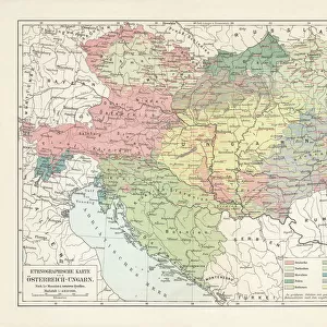
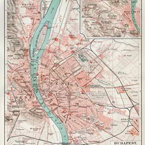
Greetings Card : Geographical Map of the Theatre of War, showing the Kingdom of Hungary in the main


![]()
Cards from Fine Art Finder
Geographical Map of the Theatre of War, showing the Kingdom of Hungary in the main
986323 Geographical Map of the Theatre of War, showing the Kingdom of Hungary in the main, 1771 (hand-coloured engraving.) by German School, (18th century); 95x116 cm; Private Collection; (add.info.: Geographical Map of the Theatre of War, showing the Kingdom of Hungary in the main; Carte Geographique du Theatre de la Guerre, en general representant le Royaume de Hongarie, by Tobias Conrad Lotter (1717-1777). German School, (18th century). Hand-coloured engraving. Printed in Augsburg, 1771. 95 x 116cm.); Photo eChristies Images; German, out of copyright
Media ID 23686772
© Christie's Images / Bridgeman Images
1770s 1771 Artist German Cartographer Eastern Europe Geographic Geographical German Art German Artist German School Green Colour Hand Colored Hand Coloring Hand Coloured Hand Colouring Hand Tinted Handcolored Hungary Kingdom Land Late 18th Century Late Eighteenth Century Navigational Equipment Old Masters Prints Profession Lotter Natural Space Theatre Of War
Greetings Card (7"x5")
Discover the historical depth of our Media Storehouse Greeting Cards with this captivating image of a Geographical Map of the Theatre of War, featuring the Kingdom of Hungary in the main. This exquisite hand-coloured engraving, hailing from the German School in 1771, brings a touch of history and culture to your correspondence. Bridgeman Images from Fine Art Finder captures this masterpiece from the past, allowing you to share a piece of art and a piece of history in one beautifully designed card. Perfect for history enthusiasts, geography lovers, or anyone seeking a unique and thoughtful greeting.
Folded Greeting Cards (12.5x17.5 cm) have a laminate finish and are supplied with an envelope. The front and inside can be personalised with text in a selection of fonts, layouts and colours.
Greetings Cards suitable for Birthdays, Weddings, Anniversaries, Graduations, Thank You and much more
Estimated Product Size is 12.5cm x 17.5cm (4.9" x 6.9")
These are individually made so all sizes are approximate
Artwork printed orientated as per the preview above, with landscape (horizontal) or portrait (vertical) orientation to match the source image.
FEATURES IN THESE COLLECTIONS
> Fine Art Finder
> Artists
> German School
> Fine Art Finder
> Artists
> Nicolas de Fer
> Fine Art Finder
> Temp Classification
> Arts
> Artists
> H
> Hungarian School Hungarian School
> Europe
> France
> Canton
> Landes
> Europe
> Hungary
> Related Images
EDITORS COMMENTS
This hand-coloured engraving, titled "Geographical Map of the Theatre of War, showing the Kingdom of Hungary in the main" takes us back to 18th century Europe. Created by German School artist Tobias Conrad Lotter and printed in Augsburg in 1771, this map measures an impressive 95x116 cm. The intricate details and vibrant colours make this piece a true masterpiece. The map showcases the Kingdom of Hungary as its focal point, with its borders clearly defined. Hand tinted in shades of green and pink, it provides a visually stunning representation of the region's geographical features. As we explore this old-world treasure, we can appreciate the skillful craftsmanship that went into creating such a detailed navigational tool. The careful hand colouring adds depth and dimension to every contour and landmark depicted on the map. With no human figures present, our attention is solely focused on appreciating nature's beauty captured within these borders. This print transports us back to a time when cartography was both an art form and an essential tool for understanding lands yet unexplored. Now part of a private collection, this German School engraving offers us a glimpse into European history during the late 18th century. Its rich colours and meticulous detail remind us why maps have always been treasured pieces of art throughout centuries past.
MADE IN AUSTRALIA
Safe Shipping with 30 Day Money Back Guarantee
FREE PERSONALISATION*
We are proud to offer a range of customisation features including Personalised Captions, Color Filters and Picture Zoom Tools
SECURE PAYMENTS
We happily accept a wide range of payment options so you can pay for the things you need in the way that is most convenient for you
* Options may vary by product and licensing agreement. Zoomed Pictures can be adjusted in the Cart.