Greetings Card > North America > United States of America > Virginia > Chesapeake
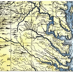
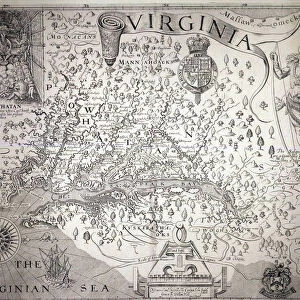
Greetings Card : VIRGINIA MAP, 1612. Captain John Smiths map of Virginia, 1612


![]()
Cards from Granger
VIRGINIA MAP, 1612. Captain John Smiths map of Virginia, 1612
Granger holds millions of images spanning more than 25,000 years of world history, from before the Stone Age to the dawn of the Space Age
Media ID 7516503
1612 Age Of Discovery American Indian Captain Chesapeake Bay Chief Colony Compass Compass Rose Powhatan Settlement Smith South Eastern Virginia
Greetings Card (7"x5")
Introducing the Media Storehouse collection of vintage greeting cards, featuring the captivating "Virginia Map, 1612" by The Granger Collection from Granger Art on Demand. This exquisite design showcases an intricately detailed map of Virginia, as drawn by renowned English explorer Captain John Smith in 1612. Transport your recipients back in time with this historically rich and beautifully illustrated card, perfect for history enthusiasts, cartography lovers, or anyone who appreciates the allure of the past. Add a touch of antiquity and curiosity to your correspondence with this unique and thoughtful greeting card from Media Storehouse.
Folded Greeting Cards (12.5x17.5 cm) have a laminate finish and are supplied with an envelope. The front and inside can be personalised with text in a selection of fonts, layouts and colours.
Greetings Cards suitable for Birthdays, Weddings, Anniversaries, Graduations, Thank You and much more
Estimated Product Size is 12.5cm x 17.5cm (4.9" x 6.9")
These are individually made so all sizes are approximate
Artwork printed orientated as per the preview above, with landscape (horizontal) or portrait (vertical) orientation to match the source image.
FEATURES IN THESE COLLECTIONS
> Maps and Charts
> Early Maps
> Maps and Charts
> Related Images
> North America
> United States of America
> Virginia
> Chesapeake
> South America
> Related Images
VIRGINIA MAP, 1612 - A Glimpse into the Early Settlements of Captain John Smith's Virginia
EDITORS COMMENTS
. This print showcases an invaluable piece of history - Captain John Smith's map of Virginia from 1612. As one gazes upon this remarkable engraving, a journey back in time unfolds, revealing the early days of English colonization in America. The map depicts the South Eastern region of Virginia, with intricate details meticulously etched onto its surface. The compass rose serves as a guide through uncharted territories during the Age of Discovery. Rivers and Chesapeake Bay are intricately illustrated, highlighting their significance for navigation and trade. Notably present on this historic document are American Indian tribes led by Chief Powhatan Wahunsenacawh. Their presence signifies the complex interactions between settlers and indigenous communities during this era. Captain John Smith's map offers a glimpse into the challenges faced by early colonists as they established settlements amidst unfamiliar landscapes. It is a testament to their resilience and determination to forge new lives in an untamed land. As we admire this Granger Collection print, let us appreciate its historical value and remember those who paved the way for future generations. This artwork invites us to reflect on our shared past while acknowledging both triumphs and tribulations that shaped America's rich tapestry.
MADE IN AUSTRALIA
Safe Shipping with 30 Day Money Back Guarantee
FREE PERSONALISATION*
We are proud to offer a range of customisation features including Personalised Captions, Color Filters and Picture Zoom Tools
SECURE PAYMENTS
We happily accept a wide range of payment options so you can pay for the things you need in the way that is most convenient for you
* Options may vary by product and licensing agreement. Zoomed Pictures can be adjusted in the Cart.