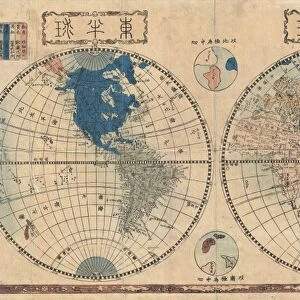
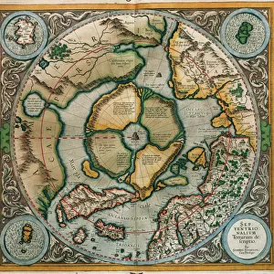
Greetings Card : 1606, Mercator Hondius Map of the Arctic, First Map of the North Pole, topography


![]()
Cards from Liszt Collection
1606, Mercator Hondius Map of the Arctic, First Map of the North Pole, topography
1606, Mercator Hondius Map of the Arctic, First Map of the North Pole
Liszt Collection of nineteenth-century engravings and images to browse and enjoy
Media ID 14004424
© Artokoloro Quint Lox Limited
1606 Antique Map Latitude Longitude Mappa Mundi Old Antique Plan Old Antique View Ols Antique Map Rare Old Maps Topo
Greetings Card (7"x5")
Discover the wonders of the Arctic with our exquisite range of greeting cards from Media Storehouse. Featuring the iconic 1606 Mercator Hondius Map of the Arctic, this design showcases the first known map of the North Pole. With intricate topography taken from the renowned Liszt Collection, each card transports you back in time to the age of exploration. Perfect for those who appreciate history and the beauty of cartography, these cards are a thoughtful and unique way to express your sentiments. Order yours today and add a touch of adventure to your correspondence.
Folded Greeting Cards (12.5x17.5 cm) have a laminate finish and are supplied with an envelope. The front and inside can be personalised with text in a selection of fonts, layouts and colours.
Greetings Cards suitable for Birthdays, Weddings, Anniversaries, Graduations, Thank You and much more
Estimated Product Size is 12.5cm x 17.5cm (4.9" x 6.9")
These are individually made so all sizes are approximate
Artwork printed orientated as per the preview above, with landscape (horizontal) or portrait (vertical) orientation to match the source image.
EDITORS COMMENTS
This print showcases the remarkable 1606 Mercator Hondius Map of the Arctic, which holds the distinction of being the first map ever created of the North Pole. With its intricate topography and meticulous cartography, this historic artifact offers a fascinating glimpse into our understanding of geography during that era. The map's detailed illustration transports us back in time to an age when exploration and discovery were at their peak. Its carefully plotted grid lines, latitude and longitude markings, and geometric precision demonstrate the immense skill and knowledge possessed by early cartographers. As we gaze upon this vintage piece of art, we are reminded of how far humanity has come in unraveling the mysteries of our planet. The aged paper and retro aesthetic add a touch of nostalgia, evoking a sense of wonder for those who appreciate historical artifacts. This rare old map serves as a testament to human curiosity and ambition. It invites us on a journey through time while igniting our own desire for adventure and exploration. Whether used for educational purposes or simply admired as an exquisite decorative piece, this antique treasure from the Liszt Collection is sure to captivate all who encounter it.
MADE IN AUSTRALIA
Safe Shipping with 30 Day Money Back Guarantee
FREE PERSONALISATION*
We are proud to offer a range of customisation features including Personalised Captions, Color Filters and Picture Zoom Tools
SECURE PAYMENTS
We happily accept a wide range of payment options so you can pay for the things you need in the way that is most convenient for you
* Options may vary by product and licensing agreement. Zoomed Pictures can be adjusted in the Cart.