Greetings Card > Arts > Artists > S > Syrian Syrian
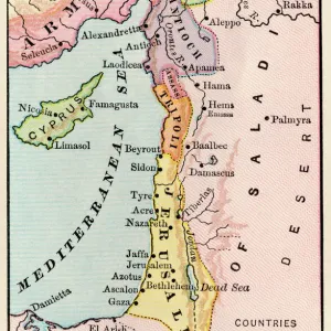
Greetings Card : 1855 Colton Map Of Turkey Iraq And Syria Topography


![]()
Cards from Universal Images Group (UIG)
1855 Colton Map Of Turkey Iraq And Syria Topography
1855, Colton Map of Turkey, Iraq, and Syria
Universal Images Group (UIG) manages distribution for many leading specialist agencies worldwide
Media ID 38549132
© Artokoloro Quint Lox Limited
1855 Iraq Antique Map Latitude Longitude Mappa Mundi Old Antique Plan Old Antique View Ols Antique Map Rare Old Maps Topo
Greetings Card (7"x5")
"Explore the wonders of the ancient world with our unique range of greetings cards featuring vintage maps from Universal Images Group (UIG). This stunning 1855 Colton Map of Turkey, Iraq, and Syria Topography is a beautiful illustration of the region's rich history. Perfect for sending to friends and family who love geography, travel, or simply appreciate the beauty of old maps. Share your appreciation for exploration and discovery with this thoughtful and educational gift."
Folded Greeting Cards (12.5x17.5 cm) have a laminate finish and are supplied with an envelope. The front and inside can be personalised with text in a selection of fonts, layouts and colours.
Greetings Cards suitable for Birthdays, Weddings, Anniversaries, Graduations, Thank You and much more
Estimated Product Size is 12.5cm x 17.5cm (4.9" x 6.9")
These are individually made so all sizes are approximate
Artwork printed orientated as per the preview above, with landscape (horizontal) or portrait (vertical) orientation to match the source image.
FEATURES IN THESE COLLECTIONS
> Animals
> Fishes
> G
> Grouper
> Arts
> Artists
> S
> Syrian Syrian
> Asia
> Iraq
> Related Images
> Asia
> Syria
> Related Images
> Asia
> Turkey
> Related Images
> Europe
> France
> Canton
> Landes
> Historic
> Space exploration
> Maps and Charts
> Early Maps
> Universal Images Group (UIG)
> History
> Historical Maps
EDITORS COMMENTS
Step back in time and explore the ancient lands of Turkey, Iraq, and Syria with this stunning 1855 Colton Map. This vintage print is a remarkable piece of cartography that showcases the topography of these regions during the mid-19th century.
The map is a testament to the skillful craftsmanship of its creator, revealing intricate details about the geography, rivers, mountains, and cities of this region. The illustration style is characteristic of its era, with ornate borders and decorative elements adding an air of elegance to the overall design.
This historic map provides a fascinating glimpse into the past, offering insights into how our understanding of these regions has evolved over time. It's a must-have for anyone interested in history, geography, or cartography.
Printed on high-quality paper and framed beautifully for display purposes only.
MADE IN AUSTRALIA
Safe Shipping with 30 Day Money Back Guarantee
FREE PERSONALISATION*
We are proud to offer a range of customisation features including Personalised Captions, Color Filters and Picture Zoom Tools
SECURE PAYMENTS
We happily accept a wide range of payment options so you can pay for the things you need in the way that is most convenient for you
* Options may vary by product and licensing agreement. Zoomed Pictures can be adjusted in the Cart.