Home > Europe > Russia > Lakes > Lake Baikal
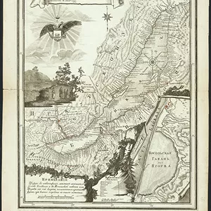
Geognostic Map of the Localities of Irkutsk, Verkholensk, and Balagansk Districts, 1873. Creator: Siberian Branch of the Russian Geographic Society

![]()
Wall Art and Photo Gifts from Heritage Images
Geognostic Map of the Localities of Irkutsk, Verkholensk, and Balagansk Districts, 1873. Creator: Siberian Branch of the Russian Geographic Society
Geognostic Map of the Localities of Irkutsk, Verkholensk, and Balagansk Districts, 1873. The first geological (geognostic) maps in Russia were produced in the 1850s. This map of the Irkutsk region was published by the Siberian Department of the Imperial Russian Geographic Society under the leadership of Academician F.B. Schmidt. It shows the location of mines and minerals, caves, gaps, salt deposits, springs, landslides, and patterns of freezing on Lake Baikal. The colors denote different types of rock
Heritage Images features heritage image collections
Media ID 35130749
© Heritage Art/Heritage Images
1870s Baikal Cartographic Cartography Cave Caves Cyrillic Geological Geology Irkutsk Rossiya Russia Lake Baikal Legend Map Making Mapmaking Mine Mineral Mines Mining Rift Lake Russian Federation Russian State Library Salt Siberia Russia Spring Landslide Meeting Of Frontiers Minerals
FEATURES IN THESE COLLECTIONS
> Europe
> Russia
> Heritage Sites
> Lake Baikal
> Europe
> Russia
> Lakes
> Lake Baikal
> Europe
> Russia
> Lakes
> Related Images
> Maps and Charts
> Early Maps
> Maps and Charts
> Geological Map
> Popular Themes
> Lake District
EDITORS COMMENTS
This print showcases the "Geognostic Map of the Localities of Irkutsk, Verkholensk, and Balagansk Districts" from 1873. Created by the Siberian Branch of the Russian Geographic Society under the guidance of Academician F.B. Schmidt, this map represents a significant milestone in Russia's geological exploration.
Dating back to the mid-19th century, geognostic maps were groundbreaking for their time. This particular map focuses on the Irkutsk region and was published with meticulous detail by utilizing various colors to denote different types of rock formations. It not only highlights mines and minerals but also sheds light on caves, gaps, salt deposits, springs, landslides, and even patterns of freezing on Lake Baikal.
The significance of this historical artifact lies in its contribution to scientific knowledge during that era. By providing valuable insights into Russia's natural resources and geographical features through cartography, it played a crucial role in shaping industrial development as well as furthering our understanding of Siberia's unique landscape.
Preserved within this image are traces of Cyrillic script alongside other symbols representing key elements such as legends denoting specific geological phenomena or landmarks. The inclusion of these details adds an extra layer to appreciate both its artistic beauty and scientific value.
Now housed at esteemed institutions like the Library Congress and Russian State Library among others, this geognostic map stands as a testament to human curiosity about our planet's inner workings. Its legacy continues to inspire future generations interested in geography, geology, history or simply captivated by its intricate design capturing a momentous period in Russia's scientific exploration.
MADE IN AUSTRALIA
Safe Shipping with 30 Day Money Back Guarantee
FREE PERSONALISATION*
We are proud to offer a range of customisation features including Personalised Captions, Color Filters and Picture Zoom Tools
SECURE PAYMENTS
We happily accept a wide range of payment options so you can pay for the things you need in the way that is most convenient for you
* Options may vary by product and licensing agreement. Zoomed Pictures can be adjusted in the Cart.