Home > Europe > Russia > Railways
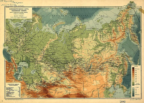
Gipsometricheskai?a? karta Rossi¯i?skoi? Imperi¯i : (opyt izobrazheni¯i?a? rel'efa Imperi¯i), (1912?) Creator: Unknown
![]()

Wall Art and Photo Gifts from Heritage Images
Gipsometricheskai?a? karta Rossi¯i?skoi? Imperi¯i : (opyt izobrazheni¯i?a? rel'efa Imperi¯i), (1912?) Creator: Unknown
Gipsometricheskai?a? karta Rossi¯i?skoi? Imperi¯i : (opyt izobrazheni¯i?a? rel'efa Imperi¯i), (1912?). Relief and depths shown by gradient tints. Also shows railroads. In Russian. Pulkovo (St. Petersburg) meridian. Includes table of extreme high elevations
Heritage Images features heritage image collections
Media ID 35129799
© Heritage Art/Heritage Images
Cartographic Cartography Cyrillic Depth Elevation Gradient Map Making Mapmaking Railroad Railways Russian Federation Meeting Of Frontiers Meridian
FEATURES IN THESE COLLECTIONS
> Maps and Charts
> Early Maps
> Popular Themes
> Railway Posters
EDITORS COMMENTS
This map print, titled "Gipsometricheskai?a karta Rossiyskoi Imperii: (opyt izobrazheniya rel'efa Imperii)," or "Geometric Map of the Russian Empire: An Attempt at Representing Its Relief," dates back to the early 1910s. The creator of this masterpiece remains unknown, adding to its allure. The map is a stunning representation of the Russian Empire during the 20th century, with a focus on the relief and depths of the terrain, depicted through the use of gradient tints. Railroads crisscross the landscape, providing a glimpse into the transportation infrastructure of the time. The map is written in Russian and displays the Pulkovo (St. Petersburg) meridian, as well as a table of extreme high elevations. The intricate details and colorful gradient shading showcase the meeting of frontiers and the diverse geography of the Russian Federation. This map is a testament to the rich history of cartography and the concept of mapmaking during the early 1900s. As a piece of heritage art, this map holds significant historical value and is a fascinating addition to any collection. Its intricate details and unique perspective offer a glimpse into the past, providing a window into the geography, transportation, and culture of the Russian Empire during the 1910s. The map's unknown origin only adds to its allure, making it a captivating and enigmatic piece that is sure to spark curiosity and fascination for generations to come.
MADE IN AUSTRALIA
Safe Shipping with 30 Day Money Back Guarantee
FREE PERSONALISATION*
We are proud to offer a range of customisation features including Personalised Captions, Color Filters and Picture Zoom Tools
SECURE PAYMENTS
We happily accept a wide range of payment options so you can pay for the things you need in the way that is most convenient for you
* Options may vary by product and licensing agreement. Zoomed Pictures can be adjusted in the Cart.


