Home > Animals > Birds > Accipitriformes > Accipitridae > Crowned Eagle
Map of North Holland, c.1700-c.1710. Creator: Nicolaes Visscher

![]()
Wall Art and Photo Gifts from Heritage Images
Map of North Holland, c.1700-c.1710. Creator: Nicolaes Visscher
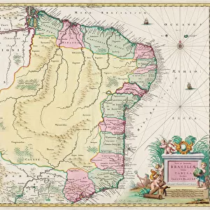
Map of North Holland, c.1700-c.1710. Kennemaria et Westfrisia vulgo et vernacule Noord-Holland tam in minores quam Praecipuas Ditiones...'. Showing the southern tip of Texel, Wieringen, Marken and a small section of South Holland. At the bottom right scale in German and French miles (1: 150, 000). At the bottom right the title, farmers with cheeses, butter and milk. At top left, dedication and putti with the imperial crown and coat of arms, allegorical figures - one holding a windmill looking at an image of a lock
Heritage Images features heritage image collections
Media ID 36341244
© Heritage Art/Heritage Images
Amorini Angelic Bird Of Prey Blazon Canal Canals Cheese Cherubim Cherubs Civil Engineering Coastline Coat Of Arms Cornucopia Dairy Dairy Product Dike Dikes Double Headed Eagle Dyke Dykes Eagle Engineering Flood Defence Heraldic Heraldry Holy Roman Empire Horn Of Plenty Island Islands Latin Lock Milk Milk Churn Milk Churns Nicolaes Visscher North Sea Peter Schenk Raptor Rivers Sand Sandbank Sandy Shield Of Arms Windmill Zuider Zee Zuiderzee Zuyder Zee Cheeses Nicolaes Visscher Ii Pieter Schenk Pieter Schenk I Putti Sandbanks Watercolour Paint
FEATURES IN THESE COLLECTIONS
> Animals
> Birds
> Accipitriformes
> Accipitridae
> Crowned Eagle
> Arts
> Artists
> S
> Petrus Schenk
> Arts
> Artists
> S
> Pieter Schenk
> Arts
> Landscape paintings
> Coastal landscapes
> Nature-inspired artwork
> Arts
> Landscape paintings
> Waterfall and river artworks
> Nature-inspired paintings
> Arts
> Watercolor paintings
> Nature-inspired watercolors
> Animal-inspired watercolors
> Arts
> Watercolor paintings
> Nature-inspired watercolors
> Waterfall and river scenes in
EDITORS COMMENTS
This exquisite map print, titled "Map of North Holland, c.1700-c.1710" by Nicolaes Visscher, offers a captivating glimpse into the geography and culture of the Dutch region during the 18th century. The map depicts a section of North Holland, including the southern tip of Texel, Wieringen, Marken, and a small portion of South Holland. The intricate detailing showcases the extensive network of canals, dikes, and windmills that were essential for flood defense and civil engineering in this low-lying area. At the bottom right of the map, a scale in both German and French miles (1: 150,000) is displayed, providing an indication of the map's accuracy and precision. The title, "Kennemaria et Westfrisia vulgo et vernacule Noord-Holland tam in minores quam Praecipuas Ditiones...," translates to "The smaller and more significant divisions of Kennemar and West Frisia, commonly known as North Holland." The top left of the map features a dedication and allegorical figures, including putti, cherubs, and an eagle holding the imperial crown and coat of arms. The eagle gazes upon an image of a lock, symbolizing the control and protection of the waterways. The surrounding landscape is adorned with cherubs, cornucopias, and other mythological elements, emphasizing the abundance of the region's agricultural resources, such as cheese, butter, and milk, which are depicted at the bottom right alongside farmers. This map is a testament to the rich artistic and historical heritage of the Dutch Golden Age, showcasing the intricate detail and beauty of the region's geography and culture. Nicolaes Visscher's mastery of engraving techniques is evident in the intricate lines and subtle shading that bring the map to life. The map is a valuable resource for scholars of Dutch history, geography, and cartography, as well as a stunning work of art in its own right.
MADE IN AUSTRALIA
Safe Shipping with 30 Day Money Back Guarantee
FREE PERSONALISATION*
We are proud to offer a range of customisation features including Personalised Captions, Color Filters and Picture Zoom Tools
SECURE PAYMENTS
We happily accept a wide range of payment options so you can pay for the things you need in the way that is most convenient for you
* Options may vary by product and licensing agreement. Zoomed Pictures can be adjusted in the Cart.