Jigsaw Puzzle > Maps and Charts > World
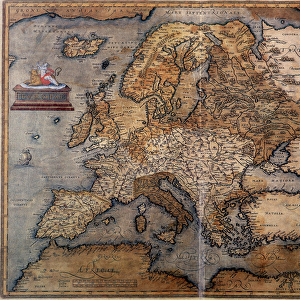
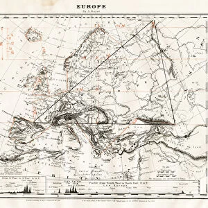
Jigsaw Puzzle : Europe map 1898


![]()
Jigsaw Puzzles from Fine Art Storehouse
Europe map 1898
Map from the Complete Handy Atlas of the World - 1898
Unleash your creativity and transform your space into a visual masterpiece!
THEPALMER
Media ID 19834477
© 2014 Roberto Adrian Photography
Jigsaw Puzzle (1000 Pieces)
Discover the rich history and geography of Europe in the early 20th century with our exquisite jigsaw puzzle from Media Storehouse. Featuring an intricately detailed map of Europe, as taken from THEPALMER's "Complete Handy Atlas of the World" published in 1898, this puzzle is a must-have for history enthusiasts and puzzle lovers alike. Immerse yourself in the intricacies of Europe's borders, cities, and landmarks as you piece together this stunning puzzle, transporting you back in time to an era of exploration and discovery. Experience the joy of completing a high-quality, beautifully designed puzzle and add a touch of history to your home or workspace.
1000 piece puzzles are custom made in Australia and hand-finished on 100% recycled 1.6mm thick laminated puzzle boards. There is a level of repetition in jigsaw shapes with each matching piece away from its pair. The completed puzzle measures 76x50cm and is delivered packaged in an attractive presentation box specially designed to fit most mail slots with a unique magnetic lid
Jigsaw Puzzles are an ideal gift for any occasion
Estimated Product Size is 76cm x 50.2cm (29.9" x 19.8")
These are individually made so all sizes are approximate
Artwork printed orientated as per the preview above, with landscape (horizontal) or portrait (vertical) orientation to match the source image.
FEATURES IN THESE COLLECTIONS
> Fine Art Storehouse
> Map
> Historical Maps
> Europe
> Related Images
> Maps and Charts
> Related Images
> Maps and Charts
> World
EDITORS COMMENTS
This print showcases a piece of history frozen in time - the Europe map from 1898. Taken from the renowned "Complete Handy Atlas of the World" this vintage treasure offers a window into an era long gone. With intricate details and exquisite craftsmanship, it transports us back to a time when cartography was both an art form and a means of exploration. The Europe map depicted here is not just any ordinary representation; it holds within its borders stories of empires rising and falling, cultures intertwining, and boundaries shifting. It serves as a visual testament to the rich tapestry that is European history. As we gaze upon this remarkable print by THEPALMER, we are reminded of how far we have come since those days. The world has evolved dramatically, yet there is something undeniably nostalgic about tracing our roots through such maps. Whether you're an avid historian or simply appreciate the beauty found in old-world charm, this print will undoubtedly captivate your imagination. Hang it proudly on your wall or gift it to someone with wanderlust in their heart - either way, let yourself be transported to a bygone era where explorers roamed these lands with curiosity and awe.
MADE IN AUSTRALIA
Safe Shipping with 30 Day Money Back Guarantee
FREE PERSONALISATION*
We are proud to offer a range of customisation features including Personalised Captions, Color Filters and Picture Zoom Tools
SECURE PAYMENTS
We happily accept a wide range of payment options so you can pay for the things you need in the way that is most convenient for you
* Options may vary by product and licensing agreement. Zoomed Pictures can be adjusted in the Cart.