Jigsaw Puzzle > Fine Art Storehouse > Map
Jigsaw Puzzle : Victorian Map of Africa


![]()
Jigsaw Puzzles from Fine Art Storehouse
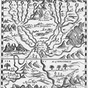
Victorian Map of Africa
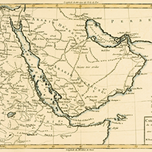
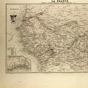
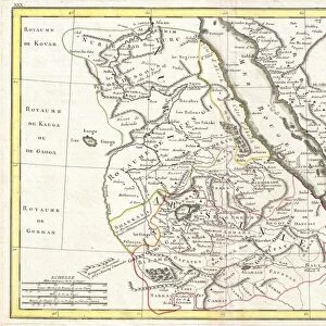
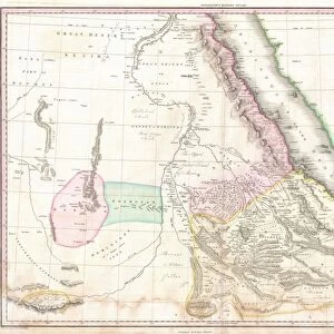
Engraved illustrations of a Map of Africa from Iconographic Encyclopedia of Science, Literature and Art, Published in 1851. Copyright has expired on this artwork. Digitally restored
Unleash your creativity and transform your space into a visual masterpiece!
bauhaus1000
Media ID 13666983
© Craig McCausland
1850 1859 British Culture Chart Country Geographic Area Diagram Drypoint English Culture Image Created 1850 1859 Isolated Isolated On White Journey Madagascar Papua New Guinea Plan Steel Engraving Sudan World Map Drawing Art Product Image Created 19th Century Victorian Style
Jigsaw Puzzle (500 Pieces)
Discover the captivating history of Africa with our Victorian Map of Africa jigsaw puzzle from Media Storehouse. This intricately detailed puzzle, featuring the engraved illustrations from the Iconographic Encyclopedia of Science, Literature and Art, published in 1851, offers a fascinating glimpse into the past. Digitally restored for optimal puzzle quality, this puzzle is a must-have for history buffs, puzzle enthusiasts, and anyone looking to expand their knowledge and appreciation for the world's diverse cultures and geography. Engage in a captivating puzzle experience and transport yourself back in time with the Media Storehouse Victorian Map of Africa jigsaw puzzle.
500 piece puzzles are custom made in Australia and hand-finished on 100% recycled 1.6mm thick laminated puzzle boards. There is a level of repetition in jigsaw shapes with each matching piece away from its pair. The completed puzzle measures 40x51cm and is delivered packaged in an attractive presentation box specially designed to fit most mail slots with a unique magnetic lid
Jigsaw Puzzles are an ideal gift for any occasion
Estimated Product Size is 50.7cm x 40.3cm (20" x 15.9")
These are individually made so all sizes are approximate
Artwork printed orientated as per the preview above, with landscape (horizontal) or portrait (vertical) orientation to match the source image.
FEATURES IN THESE COLLECTIONS
> Fine Art Storehouse
> Map
> Historical Maps
EDITORS COMMENTS
This print takes us back in time to the 19th century, immersing us in the rich history of cartography and travel. The Victorian Map of Africa, with its intricate engraved illustrations, offers a glimpse into an era when exploration was at its peak. Published in 1851 as part of the Iconographic Encyclopedia of Science, Literature and Art, this artwork is a testament to the meticulous craftsmanship that went into creating maps during that period. Digitally restored to revive its original glory, this woodcut-style image showcases not only the physical geography of Africa but also serves as a window into English and British culture at the time. From Madagascar to Sudan and even Papua New Guinea, every country's geographic area is meticulously depicted on this steel engraving. The map itself is presented on a white background, allowing each detail to stand out prominently. Its vintage charm transports us on a journey through time while reminding us of how far we have come in terms of technological advancements in cartography. Whether you are an art enthusiast or simply fascinated by historical artifacts, this print will undoubtedly captivate your imagination. It serves as both an educational tool for understanding past explorations and an exquisite piece of art that adds elegance and sophistication to any space it graces.
MADE IN AUSTRALIA
Safe Shipping with 30 Day Money Back Guarantee
FREE PERSONALISATION*
We are proud to offer a range of customisation features including Personalised Captions, Color Filters and Picture Zoom Tools
SECURE PAYMENTS
We happily accept a wide range of payment options so you can pay for the things you need in the way that is most convenient for you
* Options may vary by product and licensing agreement. Zoomed Pictures can be adjusted in the Cart.