Jigsaw Puzzle > North America > Martinique > Maps
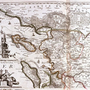
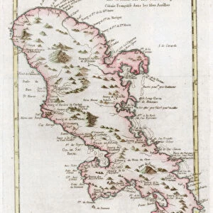
Jigsaw Puzzle : Map of the Caribbean island of Martinique, c1783


![]()
Jigsaw Puzzles from Heritage Images
Map of the Caribbean island of Martinique, c1783
Heritage Images features heritage image collections
Media ID 14953530
© The Print Collector / Heritage-Images
Caribbean Cartography Colony Indies Island Map Making Martinique Print Collector21 Topographical Topography West Indian West Indies
Jigsaw Puzzle (1000 Pieces)
Discover the rich history and culture of the Caribbean with our exquisite collection of jigsaw puzzles from Media Storehouse. This intriguing puzzle features a captivating map of the Caribbean island of Martinique, dating back to approximately 1783. The intricately detailed map, sourced from Heritage Images, showcases the island's unique geography, with its bays, peninsulas, and inlets. Assemble this beautiful puzzle to transport yourself to a time when exploration and discovery were at the forefront of human endeavor. Immerse yourself in the puzzle-solving experience and uncover the stories hidden within the lines and colors of this stunning vintage map.
1000 piece puzzles are custom made in Australia and hand-finished on 100% recycled 1.6mm thick laminated puzzle boards. There is a level of repetition in jigsaw shapes with each matching piece away from its pair. The completed puzzle measures 76x50cm and is delivered packaged in an attractive presentation box specially designed to fit most mail slots with a unique magnetic lid
Jigsaw Puzzles are an ideal gift for any occasion
Estimated Product Size is 50.2cm x 76cm (19.8" x 29.9")
These are individually made so all sizes are approximate
Artwork printed orientated as per the preview above, with landscape (horizontal) or portrait (vertical) orientation to match the source image.
FEATURES IN THESE COLLECTIONS
> Maps and Charts
> Related Images
> North America
> Martinique
> Maps
> North America
> Martinique
> Related Images
EDITORS COMMENTS
This print showcases a beautifully detailed map of the Caribbean island of Martinique, dating back to the late 18th century. Created by an unknown cartographer, this exquisite engraving offers a glimpse into the colonial era and highlights the French influence on this vibrant island. The map is adorned with vivid colors that bring to life the topography and geographical features of Martinique. From its stunning coastline that stretches along the azure waters of the Caribbean Sea to its lush interior dotted with mountains and valleys, every detail has been meticulously captured. As one explores this historic map, it becomes evident how important Martinique was as a strategic location in the West Indies during this period. Its position within the region made it a valuable colony for France, serving as a hub for trade and commerce between Europe and its colonies in America. The craftsmanship displayed in this print reflects both artistic skill and scientific precision. Map making was not only an art form but also an essential tool for exploration and navigation during these times. Today, this remarkable piece serves as a testament to our fascination with history and geography. It allows us to appreciate how far we have come while reminding us of our interconnectedness across time and space.
MADE IN AUSTRALIA
Safe Shipping with 30 Day Money Back Guarantee
FREE PERSONALISATION*
We are proud to offer a range of customisation features including Personalised Captions, Color Filters and Picture Zoom Tools
SECURE PAYMENTS
We happily accept a wide range of payment options so you can pay for the things you need in the way that is most convenient for you
* Options may vary by product and licensing agreement. Zoomed Pictures can be adjusted in the Cart.