Jigsaw Puzzle > Europe > France > Canton > Landes
Jigsaw Puzzle : 1835, S. D. U. K. City Map or Plan of Amsterdam, The Netherlands, topography, cartography


![]()
Jigsaw Puzzles from Liszt Collection
1835, S. D. U. K. City Map or Plan of Amsterdam, The Netherlands, topography, cartography
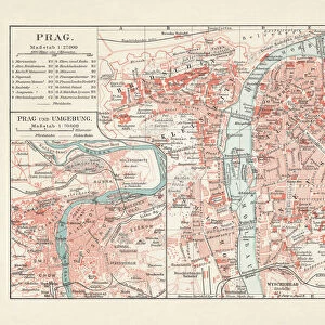
1835, S.D.U.K. City Map or Plan of Amsterdam, The Netherlands
Liszt Collection of nineteenth-century engravings and images to browse and enjoy
Media ID 14005069
© Artokoloro Quint Lox Limited
1835 The Netherlands Antique Map Latitude Longitude Mappa Mundi Old Antique Plan Old Antique View Ols Antique Map Rare Old Maps Topo
Jigsaw Puzzle (500 Pieces)
Discover the rich history of Amsterdam with our captivating jigsaw puzzle from the Media Storehouse collection. This intricately detailed puzzle features an 1835 S.D.U.K. city map or plan of Amsterdam, The Netherlands, from the esteemed Liszt Collection. Immerse yourself in the topography and cartography of this iconic European city, as you piece together the vibrant streets, canals, and historic landmarks. With hundreds of interlocking pieces, this challenging puzzle is perfect for puzzle enthusiasts and history buffs alike. Engage your mind, unwind, and transport yourself to the heart of Amsterdam.
500 piece puzzles are custom made in Australia and hand-finished on 100% recycled 1.6mm thick laminated puzzle boards. There is a level of repetition in jigsaw shapes with each matching piece away from its pair. The completed puzzle measures 40x51cm and is delivered packaged in an attractive presentation box specially designed to fit most mail slots with a unique magnetic lid
Jigsaw Puzzles are an ideal gift for any occasion
Estimated Product Size is 50.7cm x 40.3cm (20" x 15.9")
These are individually made so all sizes are approximate
Artwork printed orientated as per the preview above, with landscape (horizontal) or portrait (vertical) orientation to match the source image.
FEATURES IN THESE COLLECTIONS
> Europe
> France
> Canton
> Landes
> Europe
> Netherlands
> Amsterdam
> Europe
> Netherlands
> Maps
> Europe
> Netherlands
> Posters
> Europe
> Netherlands
> Related Images
> Historic
> Space exploration
> Maps and Charts
> Early Maps
> Maps and Charts
> Netherlands
> Maps and Charts
> Related Images
> Maps and Charts
> World
EDITORS COMMENTS
This print showcases a remarkable piece of history - the 1835 S. D. U. K. City Map or Plan of Amsterdam, The Netherlands. Immerse yourself in the rich topography and cartography depicted in this vintage map, which offers a glimpse into the city's past. With its intricate details and precise illustrations, this map serves as both an artistic masterpiece and a valuable geographic resource. As you explore this ancient artifact, you'll be transported to a bygone era when navigation relied on paper maps like these. The grid lines, latitude and longitude markings, and geometric precision demonstrate the meticulous craftsmanship that went into creating such maps during that time. The faded colors and aged appearance add to its charm while reminding us of the passage of time. This decorative piece not only captures historical significance but also evokes a sense of wanderlust for those who appreciate travel and exploration. Whether you're an avid collector or simply fascinated by old maps, this rare gem from Liszt Collection is sure to captivate your imagination. Discover Amsterdam's past through this antique view as it takes you on a journey back in time to experience the city's geography like never before.
MADE IN AUSTRALIA
Safe Shipping with 30 Day Money Back Guarantee
FREE PERSONALISATION*
We are proud to offer a range of customisation features including Personalised Captions, Color Filters and Picture Zoom Tools
SECURE PAYMENTS
We happily accept a wide range of payment options so you can pay for the things you need in the way that is most convenient for you
* Options may vary by product and licensing agreement. Zoomed Pictures can be adjusted in the Cart.