Jigsaw Puzzle > Europe > France > Canton > Landes
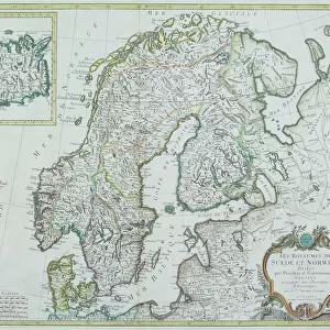
Jigsaw Puzzle : 1862 Johnson's Map Of Scandinavia Norway Sweden


![]()
Jigsaw Puzzles from Universal Images Group (UIG)
1862 Johnson's Map Of Scandinavia Norway Sweden
1862, Johnson's Map of Scandinavia, Norway, Sweden, Finland and Denmark
Universal Images Group (UIG) manages distribution for many leading specialist agencies worldwide
Media ID 38549324
© Artokoloro Quint Lox Limited
1862 Norway Sweden Antique Map Latitude Longitude Mappa Mundi Old Antique Plan Old Antique View Ols Antique Map Rare Old Maps Topo
Jigsaw Puzzle (500 Pieces)
"Get lost in the charm of Scandinavia with our Media Storehouse jigsaw puzzle featuring a stunning 1862 Johnson's Map of Scandinavia, Norway, Sweden, Finland and Denmark. This beautifully detailed map from Universal Images Group (UIG) is now transformed into a challenging and rewarding puzzle that will transport you to the region's picturesque landscapes and vibrant cities. With its intricate design and rich history, this puzzle is perfect for history buffs, geography enthusiasts, and anyone who loves a good challenge. So why not piece together the past and create your own Scandinavian adventure?"
500 piece puzzles are custom made in Australia and hand-finished on 100% recycled 1.6mm thick laminated puzzle boards. There is a level of repetition in jigsaw shapes with each matching piece away from its pair. The completed puzzle measures 40x51cm and is delivered packaged in an attractive presentation box specially designed to fit most mail slots with a unique magnetic lid
Jigsaw Puzzles are an ideal gift for any occasion
Estimated Product Size is 40.3cm x 50.7cm (15.9" x 20")
These are individually made so all sizes are approximate
Artwork printed orientated as per the preview above, with landscape (horizontal) or portrait (vertical) orientation to match the source image.
FEATURES IN THESE COLLECTIONS
> Animals
> Fishes
> G
> Grouper
> Europe
> Denmark
> Related Images
> Europe
> Finland
> Related Images
> Europe
> France
> Canton
> Landes
> Europe
> Norway
> Related Images
> Europe
> Sweden
> Related Images
> Universal Images Group (UIG)
> History
> Historical Maps
EDITORS COMMENTS
Step into the past with this stunning 1862 map of Scandinavia, Norway, Sweden, Finland, and Denmark. This beautifully detailed print from Universal Images Group (UIG) is a treasure trove of geographical knowledge and cartographic artistry.
Created in 1862 by Johnson's Mapmakers, this vintage map showcases the region's topography with intricate illustrations of mountains, rivers, and cities. The map also includes latitude and longitude lines, providing a sense of scale and precision. The delicate hand-drawn borders add an air of elegance to the overall design.
This historic map is not only a fascinating piece of geography but also a testament to the evolution of cartography over time. It offers a glimpse into how our understanding of the world has changed since its creation.
Hang this beautiful print in your home or office as a conversation starter and transport yourself back to an era when exploration was at its peak. Perfect for history buffs, geography enthusiasts, or anyone who loves vintage maps.
MADE IN AUSTRALIA
Safe Shipping with 30 Day Money Back Guarantee
FREE PERSONALISATION*
We are proud to offer a range of customisation features including Personalised Captions, Color Filters and Picture Zoom Tools
SECURE PAYMENTS
We happily accept a wide range of payment options so you can pay for the things you need in the way that is most convenient for you
* Options may vary by product and licensing agreement. Zoomed Pictures can be adjusted in the Cart.