Home > Arts > Artists > S > John Speed
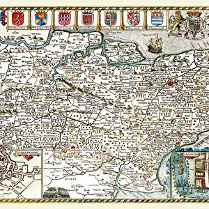
Old County Map of Warwickshire 1611 by John Speed

![]()
Wall Art and Photo Gifts from MapSeeker
Old County Map of Warwickshire 1611 by John Speed
A facimile of John Speeds historical map of Warwickshire originally published for the " Theatre of the Empire of Great Britain", an atlas to accompany " a history of Great Britain"
Welcome to the Mapseeker Image library and enter an historic gateway to one of the largest on-line collections of Historic Maps, Nostalgic Views, Vista's and Panorama's from a World gone by.
Media ID 20347749
© Mapseeker Publishing Ltd
County Map County Map Of England English County Map Historic Map John Speed Map Old County Map Old English County Map Speed Map Speede Map Warwickshire
FEATURES IN THESE COLLECTIONS
> Arts
> Artists
> S
> John Speed
> Europe
> United Kingdom
> England
> Maps
> Europe
> United Kingdom
> England
> Warwickshire
> Related Images
> Maps and Charts
> British Empire Maps
> Maps and Charts
> Early Maps
> Maps and Charts
> Related Images
> MapSeeker
> Maps from the British Isles
> England and Counties PORTFOLIO
EDITORS COMMENTS
This print showcases the "Old County Map of Warwickshire 1611" by John Speed, a renowned cartographer of his time. Originally published for the "Theatre of the Empire of Great Britain" an atlas accompanying a comprehensive history of Great Britain, this facsimile allows us to delve into the rich historical tapestry of Warwickshire. With its intricate details and elegant design, this old English county map takes us back in time to the early 17th century. The meticulous craftsmanship is evident as we explore every corner and discover towns, villages, rivers, and roads that have shaped Warwickshire's landscape throughout centuries. John Speed's expertise shines through as he presents not only geographical information but also historical context. This historic map serves as a valuable resource for researchers, historians, or anyone with an interest in tracing Warwickshire's past. It offers glimpses into how people lived during that era and provides insights into the development and growth of this fascinating county. Whether you are a collector or simply appreciate fine artistry combined with historical significance, this print is sure to captivate your imagination. Hang it on your wall or display it proudly in your study; let it transport you to a bygone era where maps were not just navigational tools but works of art themselves. Immerse yourself in the charm and allure of Warwickshire with this remarkable piece from John Speed's legacy – a testament to his enduring contribution to cartography and our understanding of England's counties' history.
MADE IN AUSTRALIA
Safe Shipping with 30 Day Money Back Guarantee
FREE PERSONALISATION*
We are proud to offer a range of customisation features including Personalised Captions, Color Filters and Picture Zoom Tools
SECURE PAYMENTS
We happily accept a wide range of payment options so you can pay for the things you need in the way that is most convenient for you
* Options may vary by product and licensing agreement. Zoomed Pictures can be adjusted in the Cart.