Home > Europe > Spain > Maps
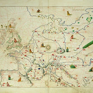
Portolan chart of the Mediterranean sea (1439)
")
![]()
Wall Art and Photo Gifts from Mary Evans Picture Library
Portolan chart of the Mediterranean sea (1439)
Portolan chart of the Mediterranean sea (1439) of Gabriel de Vallseca. It belonged to Amerigo Vespucci. SPAIN. Barcelona. Barcelona Maritime Museum
Mary Evans Picture Library makes available wonderful images created for people to enjoy over the centuries
Media ID 8260749
© Mary Evans Picture Library 2015 - https://copyrighthub.org/s0/hub1/creation/maryevans/MaryEvansPictureID/10681757
Amerigo Barcelona Belonged Cartographic Cartographies Cartography Chart Gabriel Maritime Mediterranean Mediterraneans Portolan Vespucci 15th
FEATURES IN THESE COLLECTIONS
> Maps and Charts
> Spain
EDITORS COMMENTS
1. Title: "A Glimpse into Maritime Exploration: The 15th-Century Portolan Chart of the Mediterranean Sea by Gabriel de Vallseca, Belonging to Amerigo Vespucci, Housed in Barcelona Maritime Museum" This image showcases a rare and significant piece of cartographic history - the Portolan Chart of the Mediterranean Sea, created by the Catalan cartographer Gabriel de Vallseca around 1439. This masterpiece, which once belonged to the renowned Italian explorer Amerigo Vespucci, is now proudly displayed at the Barcelona Maritime Museum in Spain. The Portolan Chart, a prime example of 15th-century cartography, represents a major advancement in the representation of the Mediterranean Sea. Its intricate detailing and accuracy were revolutionary for the medieval age, making it an essential tool for mariners navigating the Middle Sea during this period. The map's name, "Portolan," originates from the Italian word "portolano," meaning pilot or sailor. These charts were produced primarily in the Mediterranean region and were characterized by their distinctive compass roses and rhumb lines, which facilitated navigation based on a ship's course rather than true north or south. Amerigo Vespucci, an explorer famed for his voyages to the New World, acquired this chart during his extensive travels. It is believed that his possession of this valuable cartographic piece contributed to his knowledge and understanding of the Mediterranean and its surrounding waters, ultimately influencing his later explorations. Today, this exquisite Portolan Chart remains a testament to the ingenuity and curiosity of the medieval age, showcasing the remarkable progress made in cartography during this period. As a prized possession of the Barcelona Maritime Museum, it continues to inspire and educate visitors about the rich history of maritime exploration and the pivotal role the Mediterranean Sea played in shaping our world.
MADE IN AUSTRALIA
Safe Shipping with 30 Day Money Back Guarantee
FREE PERSONALISATION*
We are proud to offer a range of customisation features including Personalised Captions, Color Filters and Picture Zoom Tools
SECURE PAYMENTS
We happily accept a wide range of payment options so you can pay for the things you need in the way that is most convenient for you
* Options may vary by product and licensing agreement. Zoomed Pictures can be adjusted in the Cart.