Metal Print > Europe > France > Canton > Landes
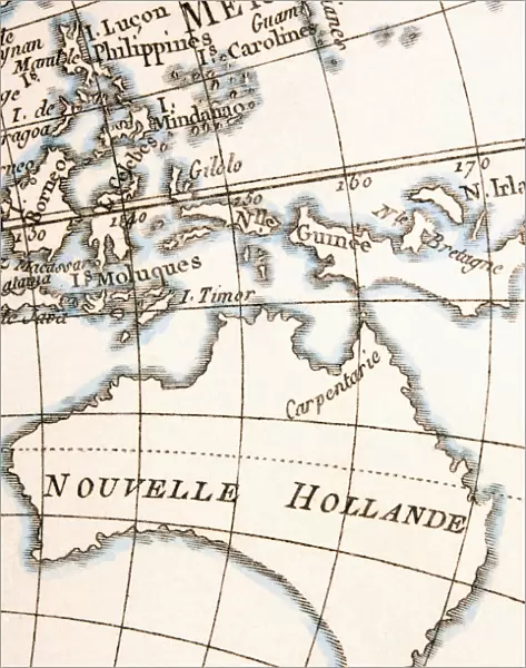
Metal Print : Australia Circa 1760. From Atlas De Toutes Les Parties Connues Du Globe Terrestre By Cartographer Rigobert Bonne Published Geneva Circa 1760


![]()
Metal Prints from Design Pics
Australia Circa 1760. From Atlas De Toutes Les Parties Connues Du Globe Terrestre By Cartographer Rigobert Bonne Published Geneva Circa 1760
Design Pics offers Distinctively Different Imagery representing over 1,500 contributors
Media ID 18196278
© Ken Welsh / Design Pics
18th Australia Bonne Cartography Circa Eighteenth Guinea Holland Joined Land Making Tasmania Diemens
14"x11" (28x35cm) Metal Print
Step back in time with our exquisite Metal Print of Australia from the Atlas De Toutes Les Parties Connues Du Globe Terrestre, published in Geneva around 1760 by renowned cartographer Rigobert Bonne. This captivating vintage map depicts Australia during an intriguing era in its discovery, showcasing intricate detail and historical accuracy. Ken Welsh from Design Pics meticulously captured the essence of this precious piece from the original antique map, making it an exceptional addition to any home or office decor. The high-quality Metal Print not only preserves the historical significance of this map but also adds a touch of timeless elegance to your space.
Our Metal Prints feature rounded corners and rear fixings for easy wall mounting. Images are directly printed onto a lightweight, high quality 5mm thick, durable metallic surface for a vivid and vibrant finish. Available in 2 sizes, 28x35cm (14x11) and 50x40cm (20x16). The unique material is fade, moisture, chemical and scratch resistant to help ensure this art lasts a lifetime.
Made with durable metal and luxurious printing techniques, metal prints bring images to life and add a modern touch to any space
Estimated Product Size is 27.9cm x 35.5cm (11" x 14")
These are individually made so all sizes are approximate
Artwork printed orientated as per the preview above, with landscape (horizontal) or portrait (vertical) orientation to match the source image.
FEATURES IN THESE COLLECTIONS
> Europe
> France
> Canton
> Landes
> Maps and Charts
> Early Maps
> Maps and Charts
> Related Images
EDITORS COMMENTS
This print takes us back in time to Australia circa 1760, a period of exploration and discovery. From the renowned Atlas De Toutes Les Parties Connues Du Globe Terrestre by esteemed cartographer Rigobert Bonne, this map was published in Geneva during the same era. The intricate details on this historical piece showcase the vastness of New Holland (now known as Australia), Tasmania (then referred to as Van Diemen's Land), and Guinea. It offers a glimpse into the 18th century cartography techniques that were employed to create such remarkable maps. As we delve into this print, we are transported to an era where making maps was both an art form and a scientific pursuit. The meticulous joining of various regions demonstrates Bonne's dedication to accuracy and precision. Ken Welsh has expertly captured this significant piece of history through his lens, allowing us to appreciate its beauty and significance even today. This print serves as a reminder of our rich past, shedding light on how early explorers navigated uncharted territories with limited resources. Let this image transport you back in time, inviting you to explore the wonders of Australia from centuries ago. Immerse yourself in the world of cartography and discover how it shaped our understanding of geography throughout history.
MADE IN AUSTRALIA
Safe Shipping with 30 Day Money Back Guarantee
FREE PERSONALISATION*
We are proud to offer a range of customisation features including Personalised Captions, Color Filters and Picture Zoom Tools
SECURE PAYMENTS
We happily accept a wide range of payment options so you can pay for the things you need in the way that is most convenient for you
* Options may vary by product and licensing agreement. Zoomed Pictures can be adjusted in the Cart.