Metal Print > Maps and Charts > Africa
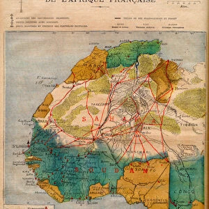
Metal Print : Map showing the Civilizations of Africa (colour litho)
")


![]()
Metal Prints from Fine Art Finder
Map showing the Civilizations of Africa (colour litho)
3649827 Map showing the Civilizations of Africa (colour litho) by European School, (19th century); Private Collection; (add.info.: Map showing the Civilizations of Africa. Illustration for The History of Mankind by Friedrich Ratzel (Macmillan, 1896).); © Look and Learn
Media ID 22239568
© Look and Learn / Bridgeman Images
Civilizations Ethnographical Ethnography
10"x8" (25x20cm) Table Top Metal Print
Discover the rich history and diversity of African civilizations with our stunning Metal Print of the Map showing the Civilizations of Africa. This captivating coloured lithograph, hailing from the European School of the 19th century, is part of the exclusive Media Storehouse collection from Fine Art Finder. Each Metal Print is meticulously crafted to bring out the intricate details and vibrant colours of this historical map. Add an element of sophistication and cultural depth to your home or office decor with this unique piece of art.
Table Top Metal Prints feature rounded corners and an easel back for easy display. Available in two sizes, 18x13cm (7x5) or 25x20cm (10x8). Lightweight and vibrant, they are perfect for displaying artwork and are guaranteed to add style to any desk or table top. The unique material is fade, moisture, chemical and scratch resistant to help ensure this art lasts a lifetime.
Made with durable metal and luxurious printing techniques, metal prints bring images to life and add a modern touch to any space
Estimated Product Size is 20.3cm x 25.4cm (8" x 10")
These are individually made so all sizes are approximate
Artwork printed orientated as per the preview above, with landscape (horizontal) or portrait (vertical) orientation to match the source image.
FEATURES IN THESE COLLECTIONS
> Fine Art Finder
> Artists
> English School
> Fine Art Finder
> Artists
> European School
> Africa
> Related Images
> Europe
> Related Images
> Maps and Charts
> Early Maps
> Maps and Charts
> Related Images
EDITORS COMMENTS
This print showcases a remarkable "Map showing the Civilizations of Africa" from the 19th century. Created by an anonymous European School artist, this colour lithograph offers a glimpse into the diverse and rich history of Africa's civilizations. The intricate details on this map highlight the ethnographical aspects of different African cultures, providing valuable insights into their historical significance. It serves as an illustration for Friedrich Ratzel's renowned book, "The History of Mankind" published in 1896 by Macmillan. With its vibrant colors and meticulous craftsmanship, this print transports viewers back in time to explore the continent's fascinating past. From ancient Egypt to powerful empires like Mali and Songhai, each civilization is carefully marked on this map, showcasing their unique contributions to Africa's cultural tapestry. As we delve deeper into this visual masterpiece, we are reminded of the importance of understanding and appreciating Africa's heritage. This print not only serves as a decorative piece but also acts as a gateway to learning about our shared human history. Displayed here with permission from Bridgeman Images' Fine Art Finder collection, it allows us to appreciate the beauty and complexity of African civilizations while acknowledging their significant impact on global culture throughout centuries.
MADE IN AUSTRALIA
Safe Shipping with 30 Day Money Back Guarantee
FREE PERSONALISATION*
We are proud to offer a range of customisation features including Personalised Captions, Color Filters and Picture Zoom Tools
SECURE PAYMENTS
We happily accept a wide range of payment options so you can pay for the things you need in the way that is most convenient for you
* Options may vary by product and licensing agreement. Zoomed Pictures can be adjusted in the Cart.