Photo Mug > Maps and Charts > Africa
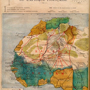
Photo Mug : Map showing the Civilizations of Africa (colour litho)
")
")

![]()
Home Decor from Fine Art Finder
Map showing the Civilizations of Africa (colour litho)
3649827 Map showing the Civilizations of Africa (colour litho) by European School, (19th century); Private Collection; (add.info.: Map showing the Civilizations of Africa. Illustration for The History of Mankind by Friedrich Ratzel (Macmillan, 1896).); © Look and Learn
Media ID 22239568
© Look and Learn / Bridgeman Images
Civilizations Ethnographical Ethnography
Photo Mug
Add a touch of history to your daily routine with our Media Storehouse Photo Mugs featuring the captivating "Map showing the Civilizations of Africa" by Bridgeman Images from Fine Art Finder. This stunning 19th century color lithograph, depicting the various civilizations across the African continent, is now transformed into a functional and beautiful mug. Each mug holds your favorite beverage while showcasing the rich history and cultural significance of Africa's ancient civilizations. Perfect for history enthusiasts, travelers, or anyone who appreciates the beauty of fine art. Embrace the past with a piece of history in your hands.
A personalised photo mug blends sentimentality with functionality, making an ideal gift for cherished loved ones, close friends, or valued colleagues. Preview may show both sides of the same mug.
Elevate your coffee or tea experience with our premium white ceramic mug. Its wide, comfortable handle makes drinking easy, and you can rely on it to be both microwave and dishwasher safe. Sold in single units, preview may show both sides of the same mug so you can see how the picture wraps around.
Mug Size is 9.6cm high x 8.1cm diameter (3.8" x 3.2")
These are individually made so all sizes are approximate
FEATURES IN THESE COLLECTIONS
> Fine Art Finder
> Artists
> English School
> Fine Art Finder
> Artists
> European School
> Africa
> Related Images
> Europe
> Related Images
> Maps and Charts
> Early Maps
> Maps and Charts
> Related Images
EDITORS COMMENTS
This print showcases a remarkable "Map showing the Civilizations of Africa" from the 19th century. Created by an anonymous European School artist, this colour lithograph offers a glimpse into the diverse and rich history of Africa's civilizations. The intricate details on this map highlight the ethnographical aspects of different African cultures, providing valuable insights into their historical significance. It serves as an illustration for Friedrich Ratzel's renowned book, "The History of Mankind" published in 1896 by Macmillan. With its vibrant colors and meticulous craftsmanship, this print transports viewers back in time to explore the continent's fascinating past. From ancient Egypt to powerful empires like Mali and Songhai, each civilization is carefully marked on this map, showcasing their unique contributions to Africa's cultural tapestry. As we delve deeper into this visual masterpiece, we are reminded of the importance of understanding and appreciating Africa's heritage. This print not only serves as a decorative piece but also acts as a gateway to learning about our shared human history. Displayed here with permission from Bridgeman Images' Fine Art Finder collection, it allows us to appreciate the beauty and complexity of African civilizations while acknowledging their significant impact on global culture throughout centuries.
MADE IN AUSTRALIA
Safe Shipping with 30 Day Money Back Guarantee
FREE PERSONALISATION*
We are proud to offer a range of customisation features including Personalised Captions, Color Filters and Picture Zoom Tools
SECURE PAYMENTS
We happily accept a wide range of payment options so you can pay for the things you need in the way that is most convenient for you
* Options may vary by product and licensing agreement. Zoomed Pictures can be adjusted in the Cart.