Metal Print > Europe > United Kingdom > Scotland > Maps
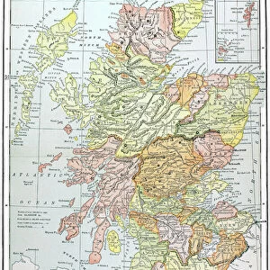
Metal Print : Antique map of Scotland


![]()
Metal Prints from Fine Art Storehouse
Antique map of Scotland
Antique map of Scotland, 1864
Unleash your creativity and transform your space into a visual masterpiece!
duncan1890
Media ID 13666661
© duncan1890
1860 1869 Aging Process Bad Condition Condition Image Created 1860 1869 Navigational Equipment Northern Europe Past Retro Revival Scotland Scottish Highlands Styles Highlands Region Image Created 19th Century Retro Styled Shetland Islands Victorian Style
10"x8" (25x20cm) Table Top Metal Print
Step back in time with our exquisite Antique Map of Scotland Metal Print from the Media Storehouse collection. This beautifully detailed reproduction, sourced from the Fine Art Storehouse, is a captivating piece of historical art by duncan1890, originally created in 1864. The vintage map showcases Scotland's rich history with intricate border designs, place names, and geographical features. Each Metal Print is meticulously crafted using premium aluminum sheets, ensuring a vibrant, long-lasting display that adds character and charm to any room. Elevate your home decor with this unique and captivating piece of art.
Table Top Metal Prints feature rounded corners and an easel back for easy display. Available in two sizes, 18x13cm (7x5) or 25x20cm (10x8). Lightweight and vibrant, they are perfect for displaying artwork and are guaranteed to add style to any desk or table top. The unique material is fade, moisture, chemical and scratch resistant to help ensure this art lasts a lifetime.
Made with durable metal and luxurious printing techniques, metal prints bring images to life and add a modern touch to any space
Estimated Product Size is 20.3cm x 25.4cm (8" x 10")
These are individually made so all sizes are approximate
Artwork printed orientated as per the preview above, with landscape (horizontal) or portrait (vertical) orientation to match the source image.
FEATURES IN THESE COLLECTIONS
> Fine Art Storehouse
> Map
> Historical Maps
> Europe
> Related Images
> Europe
> United Kingdom
> Maps
> Europe
> United Kingdom
> Scotland
> Highlands
> Related Images
> Europe
> United Kingdom
> Scotland
> Maps
> Europe
> United Kingdom
> Scotland
> Posters
> Europe
> United Kingdom
> Scotland
> Related Images
> Maps and Charts
> Related Images
EDITORS COMMENTS
This print takes us back in time to the 19th century with its antique map of Scotland. Created in 1864, this engraved image showcases the rich history and intricate cartography of that era. Despite its bad condition due to aging, the retro revival style adds a touch of nostalgia and charm. The map highlights various regions including the Scottish Highlands and Shetland Islands, providing a glimpse into Northern Europe's past. Its vertical orientation allows for easy navigation and exploration using traditional navigational equipment from that time period. With its Victorian-style aesthetics, this print transports us to an era where maps were meticulously crafted works of art. The attention to detail is evident as we observe every line and curve on this historical piece. Although devoid of people, it reminds us of the importance maps held in guiding explorers through uncharted territories. It serves as a visual representation not only of Scotland's geography but also reflects the styles prevalent during that period. Duncan1890 has captured this stunning image, preserving a slice of history for all to appreciate. Whether you are an enthusiast or simply intrigued by the past, this photograph offers a unique opportunity to immerse yourself in 19th-century cartography and experience Scotland's beauty through an antique lens.
MADE IN AUSTRALIA
Safe Shipping with 30 Day Money Back Guarantee
FREE PERSONALISATION*
We are proud to offer a range of customisation features including Personalised Captions, Color Filters and Picture Zoom Tools
SECURE PAYMENTS
We happily accept a wide range of payment options so you can pay for the things you need in the way that is most convenient for you
* Options may vary by product and licensing agreement. Zoomed Pictures can be adjusted in the Cart.