Cushion > Europe > United Kingdom > Scotland > Maps
Cushion : Antique map of Scotland


![]()
Home Decor from Fine Art Storehouse
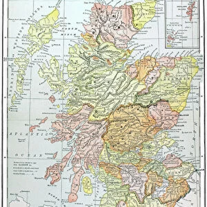
Antique map of Scotland
Antique map of Scotland, 1864
Unleash your creativity and transform your space into a visual masterpiece!
duncan1890
Media ID 13666661
© duncan1890
1860 1869 Aging Process Bad Condition Condition Image Created 1860 1869 Navigational Equipment Northern Europe Past Retro Revival Scotland Scottish Highlands Styles Highlands Region Image Created 19th Century Retro Styled Shetland Islands Victorian Style
Cushion
Refresh your home decor with a beautiful full photo 16"x16" (40x40cm) cushion, complete with cushion pad insert. Printed on both sides and made from 100% polyester with a zipper on the bottom back edge of the cushion cover. Care Instructions: Warm machine wash, do not bleach, do not tumble dry. Warm iron inside out. Do not dry clean.
Accessorise your space with decorative, soft cushions
Estimated Product Size is 40cm x 40cm (15.7" x 15.7")
These are individually made so all sizes are approximate
Artwork printed orientated as per the preview above, with landscape (horizontal) or portrait (vertical) orientation to match the source image.
FEATURES IN THESE COLLECTIONS
> Europe
> Related Images
> Europe
> United Kingdom
> Maps
> Europe
> United Kingdom
> Scotland
> Highlands
> Related Images
> Europe
> United Kingdom
> Scotland
> Maps
> Europe
> United Kingdom
> Scotland
> Posters
> Europe
> United Kingdom
> Scotland
> Related Images
> Maps and Charts
> Related Images
> Fine Art Storehouse
> Map
> Historical Maps
EDITORS COMMENTS
This print takes us back in time to the 19th century with its antique map of Scotland. Created in 1864, this engraved image showcases the rich history and intricate cartography of that era. Despite its bad condition due to aging, the retro revival style adds a touch of nostalgia and charm. The map highlights various regions including the Scottish Highlands and Shetland Islands, providing a glimpse into Northern Europe's past. Its vertical orientation allows for easy navigation and exploration using traditional navigational equipment from that time period. With its Victorian-style aesthetics, this print transports us to an era where maps were meticulously crafted works of art. The attention to detail is evident as we observe every line and curve on this historical piece. Although devoid of people, it reminds us of the importance maps held in guiding explorers through uncharted territories. It serves as a visual representation not only of Scotland's geography but also reflects the styles prevalent during that period. Duncan1890 has captured this stunning image, preserving a slice of history for all to appreciate. Whether you are an enthusiast or simply intrigued by the past, this photograph offers a unique opportunity to immerse yourself in 19th-century cartography and experience Scotland's beauty through an antique lens.
MADE IN AUSTRALIA
Safe Shipping with 30 Day Money Back Guarantee
FREE PERSONALISATION*
We are proud to offer a range of customisation features including Personalised Captions, Color Filters and Picture Zoom Tools
SECURE PAYMENTS
We happily accept a wide range of payment options so you can pay for the things you need in the way that is most convenient for you
* Options may vary by product and licensing agreement. Zoomed Pictures can be adjusted in the Cart.