Metal Print > Maps and Charts > Africa
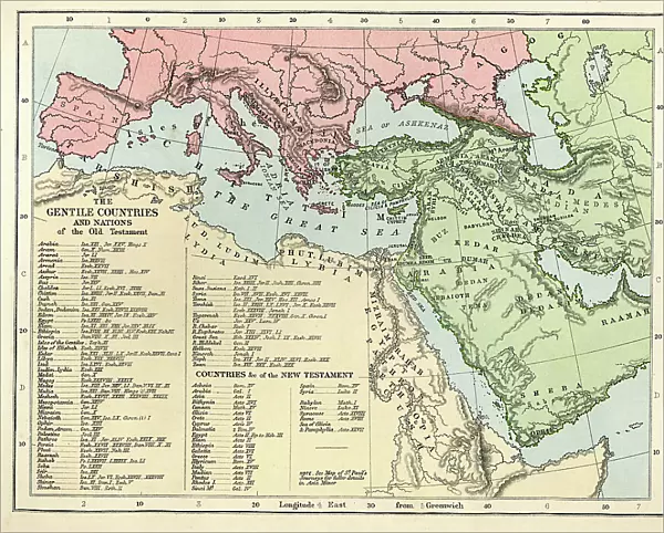
Metal Print : Old Testament Map


![]()
Metal Prints from Fine Art Storehouse
Old Testament Map
Vintage biblical map from 1879 showing the gentile countries and nations of the Old Testament
Unleash your creativity and transform your space into a visual masterpiece!
duncan1890
Media ID 31919561
© duncan1890
Ancient History Arabia Asia Pac Chart Event Mediterranean Sea Middle East Navigational Equipment New Testament North Africa Objects Equipment Old Testament Past Religious Illustration Southern Europe Styles Travel Locations Classical Style Obsolete
10"x8" (25x20cm) Table Top Metal Print
Step back in time with our Old Testament Map Metal Print from Media Storehouse. This exquisite vintage artwork, created by duncan1890 from Fine Art Storehouse, takes you on a journey through the gentile countries and nations mentioned in the Old Testament. Each detail of this 1879 map is meticulously captured in high-definition and brought to life through our premium metal printing process. The vibrant colors and stunning clarity will make this a conversation starter in any room. Add a touch of history and biblical wisdom to your space with this beautiful and intriguing piece of art.
Table Top Metal Prints feature rounded corners and an easel back for easy display. Available in two sizes, 18x13cm (7x5) or 25x20cm (10x8). Lightweight and vibrant, they are perfect for displaying artwork and are guaranteed to add style to any desk or table top. The unique material is fade, moisture, chemical and scratch resistant to help ensure this art lasts a lifetime.
Made with durable metal and luxurious printing techniques, metal prints bring images to life and add a modern touch to any space
Estimated Product Size is 25.4cm x 20.3cm (10" x 8")
These are individually made so all sizes are approximate
Artwork printed orientated as per the preview above, with landscape (horizontal) or portrait (vertical) orientation to match the source image.
FEATURES IN THESE COLLECTIONS
> Fine Art Storehouse
> Map
> Historical Maps
> Fine Art Storehouse
> World Religion
> Historic
> Ancient civilizations
> Maps and Charts
> Early Maps
> Maps and Charts
> Related Images
EDITORS COMMENTS
This vintage biblical map from 1879 takes us on a journey through the gentile countries and nations of the Old Testament. A true testament to cartography, this ancient relic showcases the intricate details of Asia Pacific, Middle East, Southern Europe, North Africa, and other regions that played significant roles in ancient history and civilization. With its classical style and religious illustrations, this antique print offers a glimpse into a bygone era. The delicate lines depict borders between nations while highlighting important travel locations throughout time. As we explore the map's faded hues and weathered edges, we are transported back to an age when navigational equipment was rudimentary yet essential for charting unknown territories. The presence of Arabia reminds us of its rich historical significance as a hub for trade routes connecting continents. Meanwhile, Asia's vastness beckons with tales of empires rising and falling across its diverse landscapes. From the Mediterranean Sea's azure depths to Africa's sprawling plains, every inch holds stories waiting to be unraveled. As we delve deeper into this piece of artistry frozen in time, it serves as a reminder that history is not just confined within textbooks but can also be experienced visually. This old-fashioned treasure allows us to connect with our past while appreciating the craftsmanship involved in creating such detailed maps centuries ago. Duncan1890 has truly preserved an invaluable piece of our collective heritage through this stunning depiction of biblical lands.
MADE IN AUSTRALIA
Safe Shipping with 30 Day Money Back Guarantee
FREE PERSONALISATION*
We are proud to offer a range of customisation features including Personalised Captions, Color Filters and Picture Zoom Tools
SECURE PAYMENTS
We happily accept a wide range of payment options so you can pay for the things you need in the way that is most convenient for you
* Options may vary by product and licensing agreement. Zoomed Pictures can be adjusted in the Cart.