Metal Print > Arts > Photorealistic artworks > Detailed art pieces > Masterful detailing in art
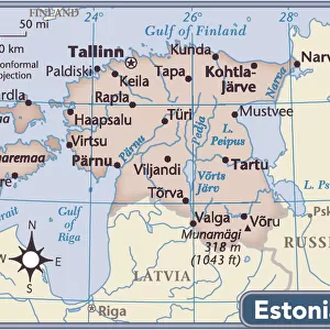
Metal Print : General Map of Livland Province: Showing Postal and Major Roads, Stations and the... 1820. Creators: Vasilii Petrovich Piadyshev, Iwanoff


![]()
Metal Prints From Heritage Images
General Map of Livland Province: Showing Postal and Major Roads, Stations and the... 1820. Creators: Vasilii Petrovich Piadyshev, Iwanoff
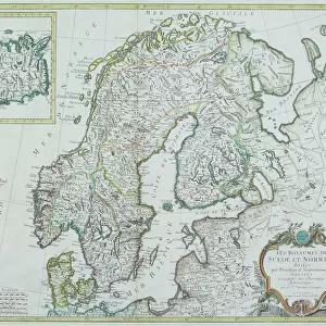
General Map of Livland Province: Showing Postal and Major Roads, Stations and the Distance in Versts between Them, 1820. This 1820 map of Livland Provinceis from a larger work, Geograficheskii atlas Rossiiskoi imperii, tsarstva Pol'skogo i velikogo kniazhestva Finliandskogo(Geographical atlas of the Russian Empire, the Kingdom of Poland, and the Grand Duchy of Finland), containing 60 maps of the Russian Empire. Compiled and engraved by Colonel V.P. Piadyshev, it reflects the detailed mapping carried out by Russian military cartographers in the first quarter of the 19th century. The map shows population centers (six gradations by size), postal stations, roads (four types), provincial and district borders, taverns, and customs houses. Distances are shown in versts, a Russian measure, now no longer used, equal to 1.07 kilometers.Legends and place-names are in Russian and German. The territory depicted on the map corresponds to the southern part of present-day Estonia and the northern part of present-day Latvia
Heritage Images features heritage image collections
Media ID 35128379
© Heritage Art/Heritage Images
1820s Border Borders Cartographer Cartographic Cartography Communication Customs House Cyrillic Estland Iwanoff Latvia Legend Livonia Map Making Mapmaker Mapmaking Military Topographical Depot Piadyshev Vasilii Petrovich Postal Station Public House Roads Russian Empire Russian Federation Tavern Thoroughfare Vasilii Petrovich Piadyshev Vp Piadyshev Meeting Of Frontiers Postal Service
10"x8" (25x20cm) Table Top Metal Print
Step back in time with our exclusive Metal Print of a historic 1820 map of Livland Province. Meticulously crafted from the original work by Vasilii Petrovich Piadyshev Iwanoff, this detailed map showcases the major roads, postal routes, and stations of the region, complete with distance measurements in versts. Add an air of antiquity and intrigue to any space with this stunning, vintage-inspired Metal Print. Perfect for history enthusiasts, collectors, or those seeking to add a touch of the past to their decor. From the Geograficheskii atlas, this is a must-have for anyone interested in the history of Livland Province.
Table Top Metal Prints feature rounded corners and an easel back for easy display. Available in two sizes, 18x13cm (7x5) or 25x20cm (10x8). Lightweight and vibrant, they are perfect for displaying artwork and are guaranteed to add style to any desk or table top. The unique material is fade, moisture, chemical and scratch resistant to help ensure this art lasts a lifetime.
Made with durable metal and luxurious printing techniques, metal prints bring images to life and add a modern touch to any space
Estimated Product Size is 25.4cm x 20.3cm (10" x 8")
These are individually made so all sizes are approximate
Artwork printed orientated as per the preview above, with landscape (horizontal) or portrait (vertical) orientation to match the source image.
FEATURES IN THESE COLLECTIONS
> Arts
> Photorealistic artworks
> Detailed art pieces
> Masterful detailing in art
> Europe
> Estonia
> Related Images
> Europe
> Finland
> Related Images
> Europe
> Latvia
> Related Images
EDITORS COMMENTS
This historic map print, titled "General Map of Livland Province: Showing Postal and Major Roads, Stations and the Distance in Versts between Them," was created by Colonel Vasilii Petrovich Piadyshev and Iwanoff in 1820. The map is a part of a larger work, "Geograficheskii atlas Rossiiskoi imperii, tsarstva Pol'skogo i velikogo kniazhestva Finliandskogo" (Geographical atlas of the Russian Empire, the Kingdom of Poland, and the Grand Duchy of Finland), which contained sixty maps of the Russian Empire. The map depicts the Livland Province, which corresponds to the southern part of present-day Estonia and the northern part of present-day Latvia. The meticulous mapping carried out by Russian military cartographers in the first quarter of the 19th century is evident in the level of detail shown on the map. The map includes various features such as population centers (six gradations by size), postal stations, roads (four types), provincial and district borders, taverns, and customs houses. Distances are shown in versts, a Russian measure now no longer used, equal to 1.07 kilometers. Legends and place-names are provided in both Russian and German. The map's intricate detail and accuracy reflect the extensive efforts made by the Russian Empire to map and explore its territories during this period. This map is a valuable historical resource, offering insights into the geography, infrastructure, and administrative divisions of the region during the early 19th century.
MADE IN AUSTRALIA
Safe Shipping with 30 Day Money Back Guarantee
FREE PERSONALISATION*
We are proud to offer a range of customisation features including Personalised Captions, Color Filters and Picture Zoom Tools
SECURE PAYMENTS
We happily accept a wide range of payment options so you can pay for the things you need in the way that is most convenient for you
* Options may vary by product and licensing agreement. Zoomed Pictures can be adjusted in the Basket.