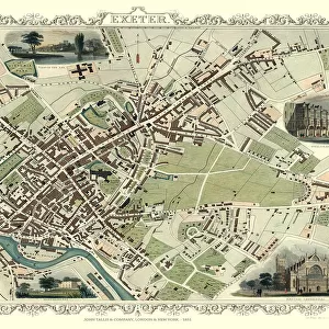
Metal Print > Europe > United Kingdom > England > London > Transport > Stations
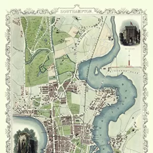
Metal Print : Old Map of Southampton 1851 by John Tallis


![]()
Metal Prints from MapSeeker
Old Map of Southampton 1851 by John Tallis
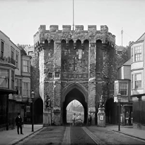
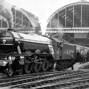
The River Itchen dominates the 1851 John Tallis plan of Southampton in Hampshire with The Parks covering a great expanse to the top left. The main illustration is a Victorian view across the shoreline to Southampton. The other three illustrations are of Netley Abbey, The Bar Gate and Railway Station at the London and South Western Railway Terminus
Welcome to the Mapseeker Image library and enter an historic gateway to one of the largest on-line collections of Historic Maps, Nostalgic Views, Vista's and Panorama's from a World gone by.
Media ID 20347588
Historic Map John Tallis John Tallis Map Old Town Plan Tallis Map
14"x11" (28x35cm) Metal Print
Discover the rich history of Southampton with our stunning Metal Prints featuring the Old Map of Southampton 1851 by John Tallis from MapSeeker. This captivating vintage map showcases the River Itchen's prominent role in the city's layout, with The Parks occupying a significant area at the top left. Each Metal Print is meticulously crafted, bringing the intricate details of this historical map to life with vibrant colors and a sleek, modern finish. Perfect for adding character to any room in your home or office, these high-quality prints are waterproof, scratch-resistant, and easy to clean. Relive the past and celebrate the unique charm of Southampton with our Old Map of Southampton 1851 Metal Print.
Our Metal Prints feature rounded corners and rear fixings for easy wall mounting. Images are directly printed onto a lightweight, high quality 5mm thick, durable metallic surface for a vivid and vibrant finish. Available in 2 sizes, 28x35cm (14x11) and 50x40cm (20x16). The unique material is fade, moisture, chemical and scratch resistant to help ensure this art lasts a lifetime.
Made with durable metal and luxurious printing techniques, metal prints bring images to life and add a modern touch to any space
Estimated Product Size is 27.9cm x 35.5cm (11" x 14")
These are individually made so all sizes are approximate
Artwork printed orientated as per the preview above, with landscape (horizontal) or portrait (vertical) orientation to match the source image.
FEATURES IN THESE COLLECTIONS
> MapSeeker
> British Town And City Plans
> English & Welsh PORTFOLIO
> Arts
> Artists
> T
> John Tallis
> Europe
> United Kingdom
> England
> Hampshire
> Netley
> Europe
> United Kingdom
> England
> Hampshire
> Park Gate
> Europe
> United Kingdom
> England
> Hampshire
> Related Images
> Europe
> United Kingdom
> England
> Hampshire
> South Town
> Europe
> United Kingdom
> England
> Hampshire
> Southampton
> Europe
> United Kingdom
> England
> London
> Transport
> Railway
> Europe
> United Kingdom
> England
> London
> Transport
> Stations
> Maps and Charts
> Related Images
> Popular Themes
> Railway Posters
EDITORS COMMENTS
This print showcases the "Old Map of Southampton 1851" by John Tallis, offering a glimpse into the rich history and charm of this coastal town in Hampshire. The map beautifully highlights the dominance of The River Itchen, gracefully meandering through Southampton's landscape. The focal point of this Victorian illustration is an enchanting view across the shoreline to Southampton itself. One can almost imagine the bustling activity that once took place along these historic streets, as ships sailed in and out of its busy port. Accompanying this main illustration are three smaller depictions that add further depth to the narrative. Netley Abbey, with its ancient ruins standing proudly amidst lush greenery, offers a glimpse into Southampton's architectural heritage. The Bar Gate stands tall and majestic, symbolizing both protection and welcoming visitors to explore what lies beyond its walls. Lastly, we see a depiction of the Railway Station at London and South Western Railway Terminus—a testament to Southampton's importance as a transportation hub during that era. As one gazes upon this old map of Southampton, it becomes evident how much has changed over time while still preserving elements from centuries past. This piece serves as a reminder of our connection to history and invites us to appreciate how far we have come since John Tallis first captured this snapshot in 1851.
MADE IN AUSTRALIA
Safe Shipping with 30 Day Money Back Guarantee
FREE PERSONALISATION*
We are proud to offer a range of customisation features including Personalised Captions, Color Filters and Picture Zoom Tools
SECURE PAYMENTS
We happily accept a wide range of payment options so you can pay for the things you need in the way that is most convenient for you
* Options may vary by product and licensing agreement. Zoomed Pictures can be adjusted in the Cart.