Metal Print > Europe > Italy > Maps
Metal Print : Map of Europe, 1600


![]()
Metal Prints from Science Photo Library
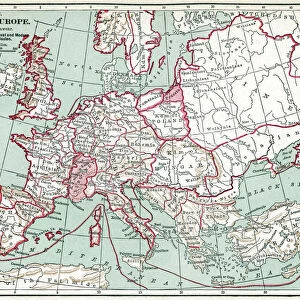
Map of Europe, 1600
16th century map of Europe. Published in Sienna in 1600, this Italian map shows the latest knowledge of the geography of Europe. The writing is in Italian, and a dedication is given at upper left in a cartouche, along with the name of the cartographer, Arnoldo di Arnoldi (died 1602). Notes are given at far right, with the title at lower right. A scale bar is at lower left
Science Photo Library features Science and Medical images including photos and illustrations
Media ID 1699833
© LIBRARY OF CONGRESS, GEOGRAPHY AND MAP DIVISION/SCIENCE PHOTO LIBRARY
1500s 1600 1600s 16th Century 17th Century Cartography Exploration Italian Medieval Middle Ages
10"x8" (25x20cm) Table Top Metal Print
Step back in time with our exquisite Media Storehouse Metal Print of the 1600 Map of Europe from Science Photo Library. This captivating 16th-century masterpiece, published in Sienna, Italy, showcases the most up-to-date geographical knowledge of Europe during that era. Experience the rich history and intricate details brought to life through our premium metal print, a perfect addition to any room that craves a touch of antiquity and exploration.
Table Top Metal Prints feature rounded corners and an easel back for easy display. Available in two sizes, 18x13cm (7x5) or 25x20cm (10x8). Lightweight and vibrant, they are perfect for displaying artwork and are guaranteed to add style to any desk or table top. The unique material is fade, moisture, chemical and scratch resistant to help ensure this art lasts a lifetime.
Made with durable metal and luxurious printing techniques, metal prints bring images to life and add a modern touch to any space
Estimated Product Size is 25.4cm x 20.3cm (10" x 8")
These are individually made so all sizes are approximate
Artwork printed orientated as per the preview above, with landscape (horizontal) or portrait (vertical) orientation to match the source image.
FEATURES IN THESE COLLECTIONS
> Arts
> Art Movements
> Medieval Art
> Maps and Charts
> Early Maps
> Maps and Charts
> Italy
> Maps and Charts
> Related Images
> Science Photo Library
> History
EDITORS COMMENTS
This print showcases a remarkable piece of history - a Map of Europe from the 16th century. Published in Sienna, Italy in the year 1600, this Italian map represents the most up-to-date knowledge of European geography at that time. The intricate details and exquisite craftsmanship make it an invaluable artifact for both cartography enthusiasts and history buffs. The writing on the map is elegantly scripted in Italian, providing a glimpse into the language used during that era. At the upper left corner, a beautifully designed cartouche contains a dedication along with the name of its creator, Arnoldo di Arnoldi (died 1602), who meticulously crafted this masterpiece. On the far right side, informative notes further enhance our understanding of Europe's geographical features. As we explore this ancient map further, we discover its title elegantly placed at lower right. Additionally, a scale bar positioned at lower left allows us to comprehend distances between various regions accurately. Transporting us back to an age when exploration was still unfolding across uncharted territories, this photograph captures not only historical significance but also serves as a testament to human curiosity and ingenuity. It reminds us how maps have played an essential role throughout centuries in shaping our understanding of the world around us. With its rich historical context and visual appeal, this print from Science Photo Library provides viewers with an opportunity to appreciate both artistry and knowledge encapsulated within one extraordinary piece.
MADE IN AUSTRALIA
Safe Shipping with 30 Day Money Back Guarantee
FREE PERSONALISATION*
We are proud to offer a range of customisation features including Personalised Captions, Color Filters and Picture Zoom Tools
SECURE PAYMENTS
We happily accept a wide range of payment options so you can pay for the things you need in the way that is most convenient for you
* Options may vary by product and licensing agreement. Zoomed Pictures can be adjusted in the Cart.