Mouse Mat > Fine Art Storehouse > Map
Mouse Mat : Map drawing technique 1881


![]()
Home Decor from Fine Art Storehouse
Map drawing technique 1881
Coltons Common School Geography 1881 New York Sheldon and Co
Unleash your creativity and transform your space into a visual masterpiece!
THEPALMER
Media ID 13669291
© This content is subject to copyright
Eastern Hemisphere Globe Navigational Equipment Hemisphere North America Paper Plan Planet Earth South America World Map
Mouse Pad
Bring some life into your office, or create a heartfelt gift, with a personalised deluxe Mouse Mat. Made of high-density black foam with a tough, stain-resistant inter-woven cloth cover they will brighten up any home or corporate office.
Archive quality photographic print in a durable wipe clean mouse mat with non slip backing. Works with all computer mice
Estimated Product Size is 24.2cm x 19.7cm (9.5" x 7.8")
These are individually made so all sizes are approximate
Artwork printed orientated as per the preview above, with landscape (horizontal) or portrait (vertical) orientation to match the source image.
FEATURES IN THESE COLLECTIONS
> Fine Art Storehouse
> The Magical World of Illustration
> Palmer Illustrated Collection
> Fine Art Storehouse
> Map
> Historical Maps
EDITORS COMMENTS
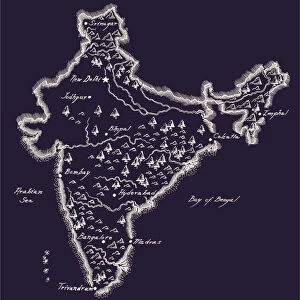
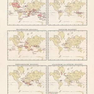
This print takes us back in time to the year 1881, where we find ourselves immersed in the fascinating world of map drawing techniques. The image showcases a page from Coltons Common School Geography, a renowned publication from that era. Published by Sheldon and Co in New York, this particular edition offers an exquisite glimpse into the artistry and precision involved in cartography during those times. The horizontal panoramic view allows us to appreciate the intricate details of this map. It spans across Europe, Africa, North America, South America, and even highlights specific regions within the United States. Surrounding the map are various navigational tools such as globes and other equipment used for charting courses on land or sea. The aged paper adds charm to this antique engraving while also reminding us of its historical significance. As we examine every line and contour meticulously etched onto this illustration, we gain insight into how early geographers visualized our planet's physical geography. With its focus on both hemispheres of Earth – particularly emphasizing Eastern Hemisphere – this print serves as a testament to humanity's relentless pursuit of knowledge about our world throughout history. "The Map Drawing Technique 1881" is not just an engraved image; it is a portal that transports us back in time to explore the wonders of cartography at its finest. THEPALMER has skillfully captured this piece from Fine Art Storehouse with utmost care and attention to detail - truly showcasing their passion for preserving these invaluable pieces of our past.
MADE IN AUSTRALIA
Safe Shipping with 30 Day Money Back Guarantee
FREE PERSONALISATION*
We are proud to offer a range of customisation features including Personalised Captions, Color Filters and Picture Zoom Tools
SECURE PAYMENTS
We happily accept a wide range of payment options so you can pay for the things you need in the way that is most convenient for you
* Options may vary by product and licensing agreement. Zoomed Pictures can be adjusted in the Cart.