Mouse Mat : Mediterranean Basin, satellite image


![]()
Home Decor from Science Photo Library
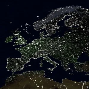
Mediterranean Basin, satellite image
Mediterranean Basin, satellite image. North is at top. The mediterranean separates the continents of Europe and Africa. The northern Mediterranean borders Spain, France, Italy, Slovenia, Greece and Turkey. In the east and south it borders Syria, Lebanon, Israel, Egypt, Libya, Algeria, Tunisia and Morocco. The Bosporus Strait joins the Mediterranean Sea to the Black Sea (top right). The Straits of Gibraltar join the Mediterranean to the Atlantic Ocean in the west
Science Photo Library features Science and Medical images including photos and illustrations
Media ID 6373367
© PLANETOBSERVER/SCIENCE PHOTO LIBRARY
Africa African Alps Arid Atlantic Ocean Black Sea Climate Continent Continents Countries Country Desert Earth Observation From Space Mediterranean Mountains Sahara Satellite Satellite Image Seas Semi Arid Topography Temerate
Mouse Pad
Bring some life into your office, or create a heartfelt gift, with a personalised deluxe Mouse Mat. Made of high-density black foam with a tough, stain-resistant inter-woven cloth cover they will brighten up any home or corporate office.
Archive quality photographic print in a durable wipe clean mouse mat with non slip backing. Works with all computer mice
Estimated Product Size is 24.2cm x 19.7cm (9.5" x 7.8")
These are individually made so all sizes are approximate
Artwork printed orientated as per the preview above, with landscape (horizontal) or portrait (vertical) orientation to match the source image.
EDITORS COMMENTS
This satellite image showcases the vastness and beauty of the Mediterranean Basin, a region that separates Europe and Africa. With its northern borders touching Spain, France, Italy, Slovenia, Greece, and Turkey, this basin is a melting pot of diverse cultures and landscapes. Moving towards the east and south, it connects with Syria, Lebanon, Israel, Egypt, Libya Algeria Tunisia Morocco. The photograph also highlights two significant waterways: the Bosporus Strait linking the Mediterranean Sea to the Black Sea in the top right corner; and the iconic Straits of Gibraltar connecting this ancient sea to the vast Atlantic Ocean in the west. From space's perspective above our planet Earth's surface lies an awe-inspiring view showcasing various geographical features. The Sahara Desert stretches across parts of North Africa while majestic mountain ranges like the Alps dominate certain areas. This image portrays both arid desert regions as well as temperate climates found throughout different countries within this region. As we gaze upon this remarkable print from Science Photo Library without any commercial intentions or affiliations mentioned here - we are reminded of how interconnected our world truly is. It serves as a reminder that despite being separated by continents and oceans - we share one planet with diverse environments waiting to be explored!
MADE IN AUSTRALIA
Safe Shipping with 30 Day Money Back Guarantee
FREE PERSONALISATION*
We are proud to offer a range of customisation features including Personalised Captions, Color Filters and Picture Zoom Tools
SECURE PAYMENTS
We happily accept a wide range of payment options so you can pay for the things you need in the way that is most convenient for you
* Options may vary by product and licensing agreement. Zoomed Pictures can be adjusted in the Cart.