Photo Mug > Fine Art Storehouse > Map
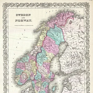
Photo Mug : Map of Denmark and Iceland, lithograph, published in 1875


![]()
Home Decor from Fine Art Storehouse
Map of Denmark and Iceland, lithograph, published in 1875
Map of Denmark and Iceland. Lithograph, published in 1875
Unleash your creativity and transform your space into a visual masterpiece!
Media ID 13666723
© ZU_09
Baltic Sea Contour Drawing Country Geographic Area Danish Culture Denmark German Culture Iceland Image Date Island Land Scandinavia Schleswig Schleswig Holstein Sweden Swedish Culture Topographic Map Topography Image Created 19th Century Obsolete
Photo Mug
Add a touch of history to your morning routine with our Media Storehouse Photo Mug featuring a stunning lithograph of a Map of Denmark and Iceland, published in 1875. This unique mug showcases intricate details of the map, transporting you back in time. Perfect for tea or coffee, this high-quality mug is not only a functional addition to your kitchen but also a beautiful piece of art to admire. Bring a piece of the Fine Art Storehouse into your home and start your day with a historical and aesthetic experience.
A personalised photo mug blends sentimentality with functionality, making an ideal gift for cherished loved ones, close friends, or valued colleagues. Preview may show both sides of the same mug.
Elevate your coffee or tea experience with our premium white ceramic mug. Its wide, comfortable handle makes drinking easy, and you can rely on it to be both microwave and dishwasher safe. Sold in single units, preview may show both sides of the same mug so you can see how the picture wraps around.
Mug Size is 8.1cm high x 9.6cm diameter (3.2" x 3.8")
These are individually made so all sizes are approximate
FEATURES IN THESE COLLECTIONS
> Fine Art Storehouse
> Map
> Denmark Maps
> Fine Art Storehouse
> Map
> Historical Maps
EDITORS COMMENTS
This lithograph, published in 1875, showcases a Map of Denmark and Iceland. A remarkable relic from the 19th century, this antique engraved image offers a glimpse into the rich history and topography of these Scandinavian lands. The map encompasses various cultural influences such as Swedish and German cultures within its borders. With its horizontal orientation, the map spans across Europe's northern region, featuring the Baltic Sea to the east and the Kattegat Sea to the west. It highlights not only Denmark and Iceland but also Schleswig-Holstein, Germany, Sweden, and other surrounding countries. The intricate contour drawing provides an accurate representation of landmasses while emphasizing important geographic features like Schleswig - a historically significant area. This topographic map serves as a testament to ancient times when Danish culture flourished alongside Icelandic traditions. Though obsolete in terms of modern cartography techniques, this lithograph remains an invaluable piece for collectors or enthusiasts interested in exploring Scandinavia's past. Its detailed craftsmanship transports viewers back in time to appreciate how these countries were shaped by their unique landscapes. Preserved with care since its creation over a century ago, this photographic print captures both the beauty and significance of this historical artifact without any human presence interrupting its essence.
MADE IN AUSTRALIA
Safe Shipping with 30 Day Money Back Guarantee
FREE PERSONALISATION*
We are proud to offer a range of customisation features including Personalised Captions, Color Filters and Picture Zoom Tools
SECURE PAYMENTS
We happily accept a wide range of payment options so you can pay for the things you need in the way that is most convenient for you
* Options may vary by product and licensing agreement. Zoomed Pictures can be adjusted in the Cart.