Poster Print > Fine Art Storehouse > Map
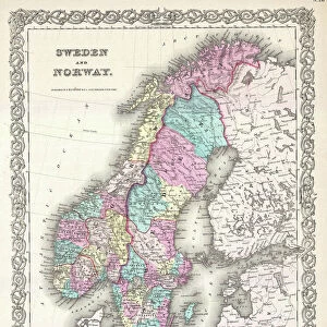
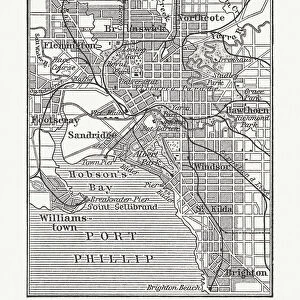
Poster Print : Map of Denmark and Iceland, lithograph, published in 1875


![]()
Poster Prints from Fine Art Storehouse
Map of Denmark and Iceland, lithograph, published in 1875
Map of Denmark and Iceland. Lithograph, published in 1875
Unleash your creativity and transform your space into a visual masterpiece!
Media ID 13666723
© ZU_09
Baltic Sea Contour Drawing Country Geographic Area Danish Culture Denmark German Culture Iceland Image Date Island Land Scandinavia Schleswig Schleswig Holstein Sweden Swedish Culture Topographic Map Topography Image Created 19th Century Obsolete
A4 (29.7 x 21cm) Poster Print
Step back in time with our exquisite Map of Denmark and Iceland Lithograph, proudly presented by Media Storehouse from our Fine Art collection. This captivating piece, published in 1875, invites you to explore the historical geography of these two fascinating Nordic countries. The intricate details and vibrant colors of this lithograph beautifully preserve the cartographic knowledge of the era, making it a must-have for history enthusiasts, collectors, and anyone who appreciates the beauty of classic maps. Bring a touch of the past into your home or office with this stunning and authentic work of art.
Premium quality poster prints are printed on luxurious semi-gloss satin 270 gsm paper. Our meticulously crafted poster prints offer an affordable option for decorating any space, making them ideal for living rooms, bedrooms, offices and beyond. To ensure your poster arrives in good condition, we roll and send them in strong mailing tubes.
Poster prints are budget friendly enlarged prints in standard poster paper sizes (A0, A1, A2, A3 etc). Whilst poster paper is sometimes thinner and less durable than our other paper types, they are still ok for framing and should last many years. Our Archival Quality Photo Prints and Fine Art Paper Prints are printed on higher quality paper and the choice of which largely depends on your budget.
Estimated Product Size is 30.3cm x 21.6cm (11.9" x 8.5")
These are individually made so all sizes are approximate
Artwork printed orientated as per the preview above, with landscape (horizontal) orientation to match the source image.
FEATURES IN THESE COLLECTIONS
> Fine Art Storehouse
> Map
> Denmark Maps
> Fine Art Storehouse
> Map
> Historical Maps
EDITORS COMMENTS
This lithograph, published in 1875, showcases a Map of Denmark and Iceland. A remarkable relic from the 19th century, this antique engraved image offers a glimpse into the rich history and topography of these Scandinavian lands. The map encompasses various cultural influences such as Swedish and German cultures within its borders. With its horizontal orientation, the map spans across Europe's northern region, featuring the Baltic Sea to the east and the Kattegat Sea to the west. It highlights not only Denmark and Iceland but also Schleswig-Holstein, Germany, Sweden, and other surrounding countries. The intricate contour drawing provides an accurate representation of landmasses while emphasizing important geographic features like Schleswig - a historically significant area. This topographic map serves as a testament to ancient times when Danish culture flourished alongside Icelandic traditions. Though obsolete in terms of modern cartography techniques, this lithograph remains an invaluable piece for collectors or enthusiasts interested in exploring Scandinavia's past. Its detailed craftsmanship transports viewers back in time to appreciate how these countries were shaped by their unique landscapes. Preserved with care since its creation over a century ago, this photographic print captures both the beauty and significance of this historical artifact without any human presence interrupting its essence.
MADE IN AUSTRALIA
Safe Shipping with 30 Day Money Back Guarantee
FREE PERSONALISATION*
We are proud to offer a range of customisation features including Personalised Captions, Color Filters and Picture Zoom Tools
SECURE PAYMENTS
We happily accept a wide range of payment options so you can pay for the things you need in the way that is most convenient for you
* Options may vary by product and licensing agreement. Zoomed Pictures can be adjusted in the Cart.